Heavy snow has encompassed much of Central NJ. This is an impressive storm! I left the house at 630am and the temperature was 40 degrees. In about 2 hours time, the temp dropped to 33 degrees, heavy snow has moved in and there is a coating on the ground. These heavy snowfall rates will have to continue to keep the accumulated snow so far. The longer the heavy snow stays around, the better for accumulations on the pavement. It does appear that heavy snow will be the norm today. The storm has pushed to the coast where it will intensify. With intensification comes heavy snow bands, and winds. A bad combination for those that like power. As the storm intensifies, there is also a better than average shot of thundersnow across the area. Late morning through evening would be prime for this!
Heavy snow will continue and eventually tapper off this evening into the night. Updates as usual on twitter @townerswxpage and facebook Towner's Weather PAGE. Enjoy!
Showing posts with label facebook. Show all posts
Showing posts with label facebook. Show all posts
Monday, March 25, 2013


Sunday, March 24, 2013
Monday/Tuesday Update (Sunday 3/24/13 morning)
The model runs last night really painted a great storm......if this was 2 months ago. 2 months ago, we would be talking about 8-12" of snow. But, since its the end of March, its a different story. NAM, GFS, EURO, Canadian models all showing a decent hit.
It will snow tomorrow most of the day, and may even be heavy at times. The problem is, it will be very tough to get anything to accumulate. The higher sun angle and the radiational heating on the pavement will limit accumulation there. Surface temperatures tomorrow will also be in the mid to upper 30's which will make it tough to even accumulate on the grassy surfaces. Look for snow to start during the early morning hours, between 6-8am.
That being said, Central and Southern NJ will be in the prime area for snowfall and if we can obtain some extremely heavy bands, we may be able to pull off a couple inches. The potential is there, tomorrow is really going to be a nowcast situation to see where the heavy bands set up.
More to come!
Saturday, March 23, 2013
Monday/Tuesday Update
Before the model runs tonight come in, just wanted to drop a note and let everyone know todays trends keep a fairly decent storm across the area. In fact, it may be a rather snowy day Monday. The bad news, most of the heaviest precipitation will be falling during the day time. A March sun angle and borderline temperatures is not a good combination for accumulations. So, it will more than likely be snowing, but it will not be accumulating. Temperatures will be in the middle 30's. We are still 36+ hours to go, so start time and max precipitation time can still be worked out.
More updates to come on this tonight and tomorrow.
More updates to come on this tonight and tomorrow.
Friday, March 22, 2013
Monday-Tuesday Potential
This upcoming Monday into Tuesday has a fairly decent storm moving into the area. There are a number of variables going into this storm, and as of now, there is a fairly decent disagreement between models. A low pressure system is poised to move towards the Ohio River Valley and then transfer to a new low in the Atlantic. Where exactly this low forms, how fast it develops and the speed will all determine what kind, if any precipitation we get.
The upper atmosphere has been cold, and there is a source for cold air. The NAM and Canadian models have rather robust outcomes while the GFS is a little weaker. The EURO has been showing this as a suppressed system but today at noon it too has brought it a little further north affecting the area. There is a fairly decent shot at a storm, and I will be following it. Best chances for accumulating snows would be at night. As of now, it looks like a Monday afternoon to early Tuesday morning event.
More to come!
Thursday, March 7, 2013
Inverted Trough Event 3/7/13 Morning Update
Well, yesterday was a prime example of what can happen when you are off on a couple variables needed for snow. The upper atmosphere was very conducive to snow, but an east wind kept surface temperatures above freezing, and kept the precipitation mainly rain with embedded snow/ice. A day of temperatures around 40 degrees kept the ground warm where even when it switched to snow last night, it was too warm to stick. Can this winter be over already?
There is a disturbance moving through the Great Lakes now that will act to cause an inverted trough from last nights storm. The disturbance will cause the trough from yesterday's storm to become inverted and act to pull back moisture from yesterday's storm. Precip is breaking out already in New England and coastal sections of NJ. This will continue to build through the day. I will monitor the situation and keep you posted. There can be some accumulations throughout the area, especially in New England and Eastern NY.
There is a disturbance moving through the Great Lakes now that will act to cause an inverted trough from last nights storm. The disturbance will cause the trough from yesterday's storm to become inverted and act to pull back moisture from yesterday's storm. Precip is breaking out already in New England and coastal sections of NJ. This will continue to build through the day. I will monitor the situation and keep you posted. There can be some accumulations throughout the area, especially in New England and Eastern NY.
Wednesday, March 6, 2013
3/6/2013 Morning Update
Areas down and around Western Virginia, West Virginia and Western Maryland are getting pounced with snow. 17" already reported in West Virginia. Thundersnow has also been reported in Western Virginia. It is snowing as far south as Richmond. As for us, precipitation has made it into the area as very light rain showers moving in via bands off the ocean. The easterly winds are really putting a hamper on surface temperatures. As the low moves east and northeast, we will gradually see our winds move to a more northerly direction which will allow the rain later to change to snows. I am still not too gung ho as others on accumulations. I am still holding with a coating - 2".
For the remainder of today. Look for more widespread and steady rain to move in. As the low moves from the VA area, our winds will shift, so when this happens is when we will see the rain / snow line move west to east. Overnight, it should be snow and it may accumulate, but again, it will more than likely be confined to grassy surfaces.
More to come,
For breaking info, pictures and observations of the storm, follow me on twitter @townerswxpage and on facebook at Towner's Weather PAGE
Here is a looping radar which is pretty neat of the storm so far:
Neat Radar Loop Of Storm (CLICK LINK)
For the remainder of today. Look for more widespread and steady rain to move in. As the low moves from the VA area, our winds will shift, so when this happens is when we will see the rain / snow line move west to east. Overnight, it should be snow and it may accumulate, but again, it will more than likely be confined to grassy surfaces.
More to come,
For breaking info, pictures and observations of the storm, follow me on twitter @townerswxpage and on facebook at Towner's Weather PAGE
Here is a looping radar which is pretty neat of the storm so far:
Neat Radar Loop Of Storm (CLICK LINK)
Tuesday, March 5, 2013
March 6th and 7th 3/5/13 morning update
While the models all bring a decent amount of precipitation to the area, there will be a vast number of conditions experienced over the area. A few days ago, we were strictly talking about possible precipitation making it into the very southern part of NJ. Now, there is a lot of potential of serious talks about a mid atlantic and northeast snowstorm. While I dont think this will be an all out snowstorm from DC to Boston, I do think there will be areas where significant snow will fall. First and foremost, the biggest part of this storm will be the effects at the shore. High Winds, rain and high seas will cause more beach erosion and flooding. Please prepare for what you can if you have interests down there.
For our area, I am still up in the air. I think areas to our south, especially the western DC burbs, Western Virginia and West Virginia are going to get a good dumping. 12" can be expected there. I also think an area of 5-9" makes it along the DC-Baltimore corridor. Then, I can also see some heavier accumulations up into the New England area after the storm moves through our area. The areas in between, specifically the Philly to NYC to New Haven, CT corridor this is the iffy part. As the storm moves to the coast, the DC/Baltimore crew will reap the benefits of the snow. As it moves to the coast, it will undergo a change and unfortunately this will be the time it is over our area. The storm will not be "bombing out" and we will have easterly winds. When a storm hits the coast and "bombs out" we can sometimes see them draw in their own cold air, creating a really unstable atmosphere (i.e. the thundersnow we received a couple years ago) and change the precipitation to snow. This time, it will not be bombing out as much, the east winds will bring warmer air in from over the ocean and keep surface temps above freezing. Surface temperatures will not fall below freezing and will remain in the mid 30's. A majority of this precipitation will be falling during the daytime hours as well. This will lead to very minimal stickage on paved surfaces. Once the low can move and our winds switch to a more northerly direction, we can see some stickage, but at the point, I would be concerned with how much snow is left.
As of now, precipitation moves in around 7am. It will more than likely be a very wet snow that will have a tough time accumulating. As the day goes on, it may transition from rain to snow and back based upon heavier bands. As the day goes on, it may be sloppy out and it will feel pretty raw. Once the sun sets, we may be able to pull out an inch or two of accumulation. More to come as this still is only a few pieces away from this being a bigger storm for the area. This is where I stand on this day, a snowy and raw day with little accumulation.
For our area, I am still up in the air. I think areas to our south, especially the western DC burbs, Western Virginia and West Virginia are going to get a good dumping. 12" can be expected there. I also think an area of 5-9" makes it along the DC-Baltimore corridor. Then, I can also see some heavier accumulations up into the New England area after the storm moves through our area. The areas in between, specifically the Philly to NYC to New Haven, CT corridor this is the iffy part. As the storm moves to the coast, the DC/Baltimore crew will reap the benefits of the snow. As it moves to the coast, it will undergo a change and unfortunately this will be the time it is over our area. The storm will not be "bombing out" and we will have easterly winds. When a storm hits the coast and "bombs out" we can sometimes see them draw in their own cold air, creating a really unstable atmosphere (i.e. the thundersnow we received a couple years ago) and change the precipitation to snow. This time, it will not be bombing out as much, the east winds will bring warmer air in from over the ocean and keep surface temps above freezing. Surface temperatures will not fall below freezing and will remain in the mid 30's. A majority of this precipitation will be falling during the daytime hours as well. This will lead to very minimal stickage on paved surfaces. Once the low can move and our winds switch to a more northerly direction, we can see some stickage, but at the point, I would be concerned with how much snow is left.
As of now, precipitation moves in around 7am. It will more than likely be a very wet snow that will have a tough time accumulating. As the day goes on, it may transition from rain to snow and back based upon heavier bands. As the day goes on, it may be sloppy out and it will feel pretty raw. Once the sun sets, we may be able to pull out an inch or two of accumulation. More to come as this still is only a few pieces away from this being a bigger storm for the area. This is where I stand on this day, a snowy and raw day with little accumulation.
Monday, March 4, 2013
March 6th and 7th Update 3/4/13 Afternoon
I talked about model chicken going on earlier, and it appears a consensus is growing. While there is still a long road to go until the final outcome, indications today are the mighty EURO is caving and moving towards the GFS. Major models, excluding the Canadian, moved north today. NAM and GFS both are big hits for DC-Boston. Euro has moved further north and is on NYC's doorstep. The Euro now puts appreciable precipitation into the Central and Southern NJ area. The 20 million dollar question now becomes temperatures. We look to have appreciable precipitation moving in, but our temperatures are going to be MARGINAL at best for snow. In fact the low pressure tracking to our south will bring an easterly wind to our area and bring air in off the ocean which is above freezing. Easterly winds and snow do not mix. Precipitation is also going to be coming in during the daytime hours and the sun angle is higher in March which will have a profound effect on accumulations on pavement. The caveat is that this could be a prolonged event and precipitation will last through the night (as modeled now). When the sun sets, if we can get temperatures cold enough for snow, we could see accumulations then.
Coastal areas are going to get hit again. I hate saying this, but an inch of water, winds 40-50mph and high seas are going to really hurt and hamper recovery efforts. There is little doubt that the shore areas will be hit hard regardless of what happens inland. Please make preparations down da shore if you own property down there.
Still a long way to go here, and a lot can happen. I am going to remain a little more conservative here until there is more compelling evidence one way or the other. I am increasingly more interested in this storm though because regardless, it has been a wild two days from nothing to a moderate to major threat for the area.
Anyways, here are some pics with the representation of events from the different models. (NOT FORECASTS, JUST SINGLE MODEL RUNS)
GFS Evening:
Surface low pressure:

Snowfall:


Coastal areas are going to get hit again. I hate saying this, but an inch of water, winds 40-50mph and high seas are going to really hurt and hamper recovery efforts. There is little doubt that the shore areas will be hit hard regardless of what happens inland. Please make preparations down da shore if you own property down there.
Still a long way to go here, and a lot can happen. I am going to remain a little more conservative here until there is more compelling evidence one way or the other. I am increasingly more interested in this storm though because regardless, it has been a wild two days from nothing to a moderate to major threat for the area.
Anyways, here are some pics with the representation of events from the different models. (NOT FORECASTS, JUST SINGLE MODEL RUNS)
GFS Evening:
Surface low pressure:

Snowfall:

NAM Evening snowfall:

EURO Midday Snowfall:

March 6th and 7th Update 3/4/13 Midday
Both the American models (NAM and GFS) show a further north track for the strom. The NAM gets sizable precip to about Interstate 195 in NJ while the GFS has sizable precipitation from DC to Boston. The Euro model last night kept a far more southern track, with very minimal precipitation making it into the area. This Euro track resembles the UKMET and Canadian models as well (keeping the southern track).
What we have here is a game of model chicken, just waiting to see who flinches first. I am still riding the Euro train and expect the storm to remain south of our area. Still, all options are on the table. More to come!
What we have here is a game of model chicken, just waiting to see who flinches first. I am still riding the Euro train and expect the storm to remain south of our area. Still, all options are on the table. More to come!
Sunday, March 3, 2013
March 6th-7th 3/3/13 Update
Models continue to hold the bulk of the precipitation to the south of us. Western Virginia and West Virginia look to get pummeled. This will work its way into the suburbs of DC. There is still a lot of uncertainty for our area, so it still has my interest. Places out even in the mid west still have a lot of uncertainty which only adds to my curiosity with this storm. Euro keeping the storm down south of us, while the GFS has been incrementally bringing it further north each run. Other models show a storm as well, but most are again south of our area.
One thing is for sure, our shore areas look once again to receive another round of battering. High tides, flooding and big waves will all batter our recovering shoreline. More to come with this storm threat.
National Weather Service Mt. Holly has issued a Hazardous Weather Outlook for the upcoming threat.
Mt Holly Hazardous Weather Outlook (Click Link)
One thing is for sure, our shore areas look once again to receive another round of battering. High tides, flooding and big waves will all batter our recovering shoreline. More to come with this storm threat.
National Weather Service Mt. Holly has issued a Hazardous Weather Outlook for the upcoming threat.
Mt Holly Hazardous Weather Outlook (Click Link)
Thursday, February 14, 2013
Recap And The Weekend Ahead
Surface temperatures yesterday during the day really hampered our efforts to get a good accumulating snow. Even when the snow rates increased, it was tough to accumulate due to the surface warmth and the water that had already accumulated on the ground. If we have had that snow a week ago when our highs were in the 20's, we would have had a nice little event. Anyways, time to move on.
I wrote earlier this week about the potential for a storm this weekend. It was being shown on the models a couple days ago, and then went away. Well, the idea of a weekend storm are back. The noon time runs today are showing the potential to be there for our area into the Northeast. These periods of time when multiple storms are showing up on models, it becomes difficult for them to key in on each one. This is one of the reasons why I have felt that it was possible for this weekend, because the positioning of a lot of other elements are present. Sometimes it just takes one storm to conclude before models pick up on the other pieces of energy.
A quick look at the midday model runs has the GFS showing a very nice coastal storm taking shape of the coast in the southeast moving up the coast (moderate storm). The NAM is similar (although not totally honed in yet) and the Canadian model also shows an event like the NAM. The Euro just came out, and has an event, but much lighter. I have not looked at surface temps on each preceding them, but tomorrow is supposed to be warm. In addition, a arctic trough will be settling in just before or concurrent for the storm. Things may get interesting.
I will have more to come over the day and a more detailed post tonight. Just be prepared that a significant storm can potentially come to fruition within a couple days.
Happy Valentines Day to everyone!
Tuesday, February 12, 2013
Tuesday 2/12/2013 Morning Update
Increasingly more confident of measurable snows moving into the area for Wednesday Night into Thursday. Over the past 24 hours, models have kept the measurable precipitation SOUTH of areas just bombarded (CT, NYC etc). For those areas a coating to 1" can be expected. From NYC South to Trenton 1-2" looks good. From the Trenton area south towards Philly 2-4" is my call, and areas south of that, while seeing more precipitation, you will have serious surface temperature issues preventing a lot of accumulation 1-3" down there. In any case, this looks to be a quick hitter. precipitation moves in between 6pm and 8pm and is out by 7am.
For the weekend there still remains a lot of questions. Most major models are not showing anything resembling a monster storm. The UKMET is probably the closest, but for now remaining cautiously optimistic about the event. More to come on this.
For the weekend there still remains a lot of questions. Most major models are not showing anything resembling a monster storm. The UKMET is probably the closest, but for now remaining cautiously optimistic about the event. More to come on this.
Monday, February 11, 2013
Verification From Blizzard 02/08/2013
Quick Verification from the Blizzard. Always room for improvement,
Predicted Amounts from 2/7/2013
Philly south to NE MD: 1-3"
Philly North to 195 3-6"
195 North to 78 6-10"
78- NYC 10-12"
Lower Hudson Valley - RT 91 in CT 12-20"
RT 91 to East Coast 20-30"
Blog Entry From 2/7/2013
____________________________________________________________________________
Courtesy NWS: Snowfall Map Blizzard 2/8/13-2/9/13

Predicted Amounts from 2/7/2013
Philly south to NE MD: 1-3"
Philly North to 195 3-6"
195 North to 78 6-10"
78- NYC 10-12"
Lower Hudson Valley - RT 91 in CT 12-20"
RT 91 to East Coast 20-30"
Blog Entry From 2/7/2013
____________________________________________________________________________
Courtesy NWS: Snowfall Map Blizzard 2/8/13-2/9/13

Monday 2/11/2013 Afternoon Update
Wednesdays storm looks a little better today on the weather models. Every major model has precipitation into Central Jersey. The big question is going to be precipitation type. Surface temperatures are looking questionable for the start of the storm. may be one of those situations of a mix to snow. At this point, more focused on the threat of a storm than precip types. Credit to the GFS this storm, it has been onto this for a couple days and it appears other models are moving towards it.
The other aspect which has looked really good on the models this morning is for this weekend. I mentioned this morning about the potential for a potent storm, and it is showing up on models. This storm has some serious potential for the area. The GFS model showed a very nice hit and the Euro has some improving pieces (but not quite there yet). The British UKMET model is all over this already and shows an absolute bomb! Tally ho! I really think this will be the one. The overall pattern supports it, and I think tonight's run of the EURO will have it finally.
Just an FYI, sometimes when I tweet out an update from a model run, I am not very specific and you probably see some weird times etc. The major models I look at are all based off Greenwich meantime. You will see a lot of times 00z, 18z etc etc. Those times are the time (2400 military) minus 5 hours (for eastern standard time). So, the 00z NAM run would really be the model run from 7pm, 6z is the 1am run etc. There is an entire page on my blog devoted to the models and the time the DATA comes out. Some are used in the short range, some are more long term. Here is the link:
WEATHER MODEL INFORMATION (CLICK LINK)
More to come! As always, any questions, let me know.
The other aspect which has looked really good on the models this morning is for this weekend. I mentioned this morning about the potential for a potent storm, and it is showing up on models. This storm has some serious potential for the area. The GFS model showed a very nice hit and the Euro has some improving pieces (but not quite there yet). The British UKMET model is all over this already and shows an absolute bomb! Tally ho! I really think this will be the one. The overall pattern supports it, and I think tonight's run of the EURO will have it finally.
Just an FYI, sometimes when I tweet out an update from a model run, I am not very specific and you probably see some weird times etc. The major models I look at are all based off Greenwich meantime. You will see a lot of times 00z, 18z etc etc. Those times are the time (2400 military) minus 5 hours (for eastern standard time). So, the 00z NAM run would really be the model run from 7pm, 6z is the 1am run etc. There is an entire page on my blog devoted to the models and the time the DATA comes out. Some are used in the short range, some are more long term. Here is the link:
WEATHER MODEL INFORMATION (CLICK LINK)
More to come! As always, any questions, let me know.
Monday February 11, 2013 Morning Discussion
Some areas this morning had icy conditions. Areas from Central Jersey south have transitioned to all rain as temperatures have risen well above freezing. A frontal boundary is moving through with a low pressure to our west. With that setup, we get flooded with warmer air aloft and eventually down to the surface. Areas further north that have a substantial amount of snow will stay with the freezing rain a little longer due to the fact that your surface temperatures are colder due to the snow. Eventually, all areas will transition to plain rain.
A lot going on this week. First, for the period Wednesday and Thursday we have a potential coastal storm development. Most models have some sort of storm (although they get here through different tracks) for our area. The usual questions remain; track, intensity etc. Biggest question for me right now is surface temperatures. As it looks now, would more than likely be a mix to snow for Central Jersey and snow north and west. Coastal areas would be rain and some backside snows possibly. Hopefully over the next day we can nail this down.
Then to the weekend. This would be the period from Saturday Night through Sunday Night. We have another modeled storm that could be a bit more substantial. A lot to work out with this storm, and I am going to focus on the Wednesday - Thursday storm first. There is potential though for another coastal storm. We have had a number of storms affect our area during the Presidents weekend time frame, and this could be another case.
A lot going on this week. First, for the period Wednesday and Thursday we have a potential coastal storm development. Most models have some sort of storm (although they get here through different tracks) for our area. The usual questions remain; track, intensity etc. Biggest question for me right now is surface temperatures. As it looks now, would more than likely be a mix to snow for Central Jersey and snow north and west. Coastal areas would be rain and some backside snows possibly. Hopefully over the next day we can nail this down.
Then to the weekend. This would be the period from Saturday Night through Sunday Night. We have another modeled storm that could be a bit more substantial. A lot to work out with this storm, and I am going to focus on the Wednesday - Thursday storm first. There is potential though for another coastal storm. We have had a number of storms affect our area during the Presidents weekend time frame, and this could be another case.
Sunday, February 10, 2013
Freezing Rain Advisory, Mercer and NW Counties
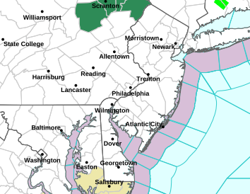
the NWS has issued freezing rain advisories for areas NW of Mercer and Northern Bucks Counties. Please be careful if driving through tomorrow am. Temperatures will rise tomorrow and everyone will go over to rain.

Thursday, February 7, 2013
All In..... Here We Go!
I have been talking over the past couple of days about it all coming down to the phasing. Well, it does. And, what the models have been showing today is an earlier phase, creating a colder solution, more intense storm, and more precipitation. While there is more precipitation, it doesn't mean we escape rain free everywhere. Many areas in Central NJ will wake up to snow tomorrow that will change to rain. Don't fret, this is an overrunning event from the southern low pressure. Although it changes to rain, it will change back to snow during the afternoon hours. This will be due to the phase of the southern and northern storms. The northern storm will be bringing the cold air to the party. Tomorrow night may be pretty wild even down into Philly.
After seeing two bombs on the NAM model, the Euro holding serve, GFS still showing moderate snows and the SREF models trending colder with identical precipitation amounts, its time. Time to go all in and up some amounts.
From Allentown, PA to Newark (Rt 78) and NYC north, this will be an all snow event. areas south of there will start as snow, go over to a mix and rain, and then back to snow. Tomorrow night will produce heavy snows, possible thundersnow and snowfall rates of up to an inch an hour. A lot of that will be nowcasted, which I will post on twitter and facebook.
SNOWFALL AMOUNTS:
Philly south to NE MD: 1-3"
Philly North to 195 3-6"
195 North to 78 6-10"
78- NYC 10-12"
Lower Hudson Valley - RT 91 in CT 12-20"
RT 91 to East Coast 20-30"
these are my conservative numbers now. Pretty confident throwing these out there.
follow laong on twitter and facebook tomorrow for up to the minute updates and things to keep an eye on.
Stay Safe
Oh- and a special shout out to Rose and Susan from BEI, thanks for following!
New England Historic Storm Taking Shape
If there is one thing that is pretty certain here, is that New England is going to get smoked. These estimates of 24-30" of snow are realistic. This is going to be an old fashioned, New England blizzard. For the rest of us, from NYC south, the uncertainty remains king. We are dealing with two separate low pressures. One, a disturbance diving out of Canada towards the East Coast. The other, a low pressure in the Gulf States. These two low pressures will phase, or merge, along the East Coast and move ENE around the "benchmark"
EDIT- I have mentioned the "benchmark" on several posts, but I have probably not done a good job explaining why this is important. The "benchmark" is located at 40N and 70W and the significance is that a large majority of winter storms pass over this area bringing the perfect balance of distance to bring the biggest storms.
So, the questions remain where exactly these two low pressures phase, how phased the evolving storm can intensify, speed of travel and track of the storm. Each model is still showing some different outcomes based on these variables. Each model is also able to pick up on subtle characteristics that are making the forecast very difficult. Overnight, the NAM model had zero snow for Philly. The GFS showed a couple inches for Philly and the Euro was like 6" for Philly. Whats more mind boggling is while Boston is looking at 30", NYC could very well hit 12" of snow, while Philly sits at zero. This is the type of spread we have. Any earlier phase, we could be looking at substantial snows. Any later, or a further east track, we will be looking at showers with next to nothing.
For now, I am going with snow starting very early tomorrow morning (5- 7 am). Late morning we switch to mixed precipitation and rain. Late afternoon we switch back to snow and may get some period of moderate snows. I think from 195 north to NYC, 3-6" can be expected while areas from 195 south to Philly can expect 1-3". This is based on my current thoughts, but confidence is still low on this. By tonight I will issue a final. Places in NW NJ and the Lower Hudson Valley 8-12" can be expected while areas to the east from I87 - I91 12-20" and then from I91-East Coast 20-30".
Please remember for those areas looking to get walloped that this will be a rapidly intensifying storm and the winds will be whipping. There is also a higher than normal chance for thundersnow. Snowfall rates will easily make 1-3"/hour in many locations, if not more. This will be a very intense and dangerous storm.
EDIT- I have mentioned the "benchmark" on several posts, but I have probably not done a good job explaining why this is important. The "benchmark" is located at 40N and 70W and the significance is that a large majority of winter storms pass over this area bringing the perfect balance of distance to bring the biggest storms.
So, the questions remain where exactly these two low pressures phase, how phased the evolving storm can intensify, speed of travel and track of the storm. Each model is still showing some different outcomes based on these variables. Each model is also able to pick up on subtle characteristics that are making the forecast very difficult. Overnight, the NAM model had zero snow for Philly. The GFS showed a couple inches for Philly and the Euro was like 6" for Philly. Whats more mind boggling is while Boston is looking at 30", NYC could very well hit 12" of snow, while Philly sits at zero. This is the type of spread we have. Any earlier phase, we could be looking at substantial snows. Any later, or a further east track, we will be looking at showers with next to nothing.
For now, I am going with snow starting very early tomorrow morning (5- 7 am). Late morning we switch to mixed precipitation and rain. Late afternoon we switch back to snow and may get some period of moderate snows. I think from 195 north to NYC, 3-6" can be expected while areas from 195 south to Philly can expect 1-3". This is based on my current thoughts, but confidence is still low on this. By tonight I will issue a final. Places in NW NJ and the Lower Hudson Valley 8-12" can be expected while areas to the east from I87 - I91 12-20" and then from I91-East Coast 20-30".
Please remember for those areas looking to get walloped that this will be a rapidly intensifying storm and the winds will be whipping. There is also a higher than normal chance for thundersnow. Snowfall rates will easily make 1-3"/hour in many locations, if not more. This will be a very intense and dangerous storm.
Wednesday, February 6, 2013
Wednesday Morning Update For Friday
As mentioned yesterday, the EURO model has been very very consistent with a significant East Coast storm for a number of successive runs now. This has continued. Not only has it continued, but every run seems to signify a bigger storm. By bigger, I mean affecting more areas. yesterdays midday run was a huge run for areas in New England. As I wrote yesterday, the low pressure was centered off the Carolina coast and moved to the "benchmark" and really hammered New England (specifically the Boston to Maine area). This track and intensity was a bit too late for areas south of NYC.
Last nights overnight EURO run actually shows a low pressure taking shape at the NC/SC border. From here it moves up and rapidly strengthens and brings measurable snowfall into the Philadelphia - NYC corridor. So, this will actually have to be watched to see if this continues. The GFS model did not even show this type of setup 1.5 days ago, but has really trended towards the EURO model. For now, the GFS keeps this as a New England event, with some rain changing over to snow for our area. The NAM (which we are on the outskirts of its range) shows a unphased dual low scenario bringing rain showers to the area.
What else to note, the RPM model has shown this morning a significant snowfall (more so than the EURO) for the NJ area as well as New England. This is again another one of those things we will have to watch to see if this continues. All in all, there is more frozen precipitation on the table today as compared to yesterday. There is a long way to go to bring frozen precipitation to our area. I am much more enthusiastic about this compared to yesterday. Finger crossed!
Last nights overnight EURO run actually shows a low pressure taking shape at the NC/SC border. From here it moves up and rapidly strengthens and brings measurable snowfall into the Philadelphia - NYC corridor. So, this will actually have to be watched to see if this continues. The GFS model did not even show this type of setup 1.5 days ago, but has really trended towards the EURO model. For now, the GFS keeps this as a New England event, with some rain changing over to snow for our area. The NAM (which we are on the outskirts of its range) shows a unphased dual low scenario bringing rain showers to the area.
What else to note, the RPM model has shown this morning a significant snowfall (more so than the EURO) for the NJ area as well as New England. This is again another one of those things we will have to watch to see if this continues. All in all, there is more frozen precipitation on the table today as compared to yesterday. There is a long way to go to bring frozen precipitation to our area. I am much more enthusiastic about this compared to yesterday. Finger crossed!
Tuesday, February 5, 2013
A Threat Looming?
A horrid winter trudges on for those loving snow. Each run of the models brings optimism and excitement, but this year usually leads to a let down. Rain / snow line a bit west, north, temperatures a bit to warm, precipitation just not breaking out, the list continues.
Here we go once again. A lot of talks about a storm on Friday. The EURO had this for a number of consecutive runs (which usually means something). The GFS has now moved to the idea of a Noreaster taking shape on Friday. This does look to be a significant storm, and someone will get a lot of snow. Right now, my money is on New England. I will say this as well, the GFS has trended cooler each run which does mean, any cooler we too could be looking at snow here too.
For now, a low pressure will phase with a northern stream disturbance off the coast of NC. From here, it will move up the east coast and come close to the "benchmark". The usual factors will need to be looked at here as always.....strong high pressure to the north, blocking, avail cold air, track, intensity etc. As for now, keep in your mind a storm is possible, with a lot of details to work out.
Subscribe to:
Posts (Atom)