Showing posts with label severe. Show all posts

Monday, October 7, 2013

Tornado Watch In Effect

For All Of NJ:

Yellow areas:


Tornado Watch

TORNADO WATCH OUTLINE UPDATE FOR WT 543
NWS STORM PREDICTION CENTER NORMAN OK
900 AM EDT MON OCT 7 2013

TORNADO WATCH 543 IS IN EFFECT UNTIL 500 PM EDT FOR THE
 FOLLOWING LOCATIONS

NJC001-003-005-007-009-011-013-015-017-019-021-023-025-027-029-
031-033-035-037-039-041-072100-
/O.NEW.KWNS.TO.A.0543.131007T1300Z-131007T2100Z/

NJ
.    NEW JERSEY COUNTIES INCLUDED ARE

ATLANTIC             BERGEN              BURLINGTON
CAMDEN               CAPE MAY            CUMBERLAND
EASTERN UNION        ESSEX               GLOUCESTER
HUDSON               HUNTERDON           MERCER
MIDDLESEX            MONMOUTH            MORRIS
OCEAN                PASSAIC             SALEM
SOMERSET             SUSSEX              WARREN
$$

Stormy Day On Tap?

Finally, we will be able to push this warm and humid airmass out of here today. A cold front is pushing east today and will bring with it much relief from the humid airmass. Along with the frontal passage, will be heavy rains, winds and isolated tornadoes. Once the front passes through, we will once again have temperatures in the low 70's with low humidity!

SPC values today:

Severe Weather:


Tornadoes:

Winds:

Monday, June 24, 2013

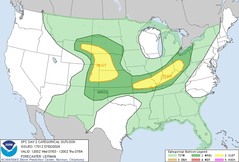
Thunderstorms For Areas Outlined By SPC

...STRONG THUNDERSTORMS WILL AFFECT PARTS OF EXTREME NORTHERN DELAWARE...SOUTHEASTERN PENNSYLVANIA AND SOUTHERN NEW JERSEY...

AT 225 PM EDT...NATIONAL WEATHER SERVICE DOPPLER RADAR INDICATED A LINE OF STRONG THUNDERSTORMS EXTENDING FROM SOUTHERN CHESTER COUNTY AND DELAWARE COUNTY IN PENNSYLVANIA TO NORTHERN BURLINGTON COUNTY AND NORTHERN OCEAN COUNTY IN NEW JERSEY. THE THUNDERSTORMS WERE MOVING SLOWLY TO THE EAST. WIND GUSTS TO 40 MPH AND PENNY SIZE HAIL ARE POSSIBLE WITH THESE STORMS. EXPECT INTENSE LIGHTNING. DO NOT STAY IN THE OPEN NOR SEEK SHELTER UNDER TREES WHEN LIGHTNING THREATENS. MOVE INDOORS WHEN A THUNDERSTORM APPROACHES. VERY HEAVY RAIN WILL FALL FROM THESE STORMS AND IT WILL CAUSE WATER TO POND ON ROADS AND FILL POOR DRAINAGE AREAS.

Wednesday, June 12, 2013

June 12th Severe Weather Update

I had posted earlier about a potential severe weather event for tomorrow in our area. This still looks to be on track. Today, numerous severe thunderstorms and tornadoes have taken place in the Upper Midwest and now into the Ohio River Valley. These storms will move east and start to affect the the area overnight. While rain and possible some minor thunderstorms move in, the real event will be tomorrow afternoon.

The general breakdown will be heavy rains to the north and severe weather south. Central Jersey is going to be kind of a dividing line. The whole event hinges on the placement of a warm front. The warm front will be the dividing line between the two outcomes. If you are south of the warm front, you can expect rain and severe weather. North of the front, it will be a primarily heavy rain event. Areas north are looking at 2-4" of rain while areas to the south are looking 1-2" and the severe weather. The severe weather will be severe thunderstorms, dangerous lightening, hail, damaging winds and even a tornado threat. Remember too, our area has already received a lot of rain, and any additional can spell bad news on saturated grounds and rivers.

As of now, that warm front is poised to set up in north central NJ. As with all systems, timing will be key. A lot can change, but it would be a good idea to pay attention tomorrow. Having an alerting mechanism will be a good idea tomorrow either on your phone, radio or TV in case you get one of these storms.As always, I will be doing updates on twitter (@townerswxpage) and facebook (Towner's Weather PAGE).

Thursday, May 23, 2013

Wednesday, February 6, 2013

Wednesday Morning Update For Friday

As mentioned yesterday, the EURO model has been very very consistent with a significant East Coast storm for a number of successive runs now. This has continued. Not only has it continued, but every run seems to signify a bigger storm. By bigger, I mean affecting more areas. yesterdays midday run was a huge run for areas in New England. As I wrote yesterday, the low pressure was centered off the Carolina coast and moved to the "benchmark" and really hammered New England (specifically the Boston to Maine area). This track and intensity was a bit too late for areas south of NYC.

Last nights overnight EURO run actually shows a low pressure taking shape at the NC/SC border. From here it moves up and rapidly strengthens and brings measurable snowfall into the Philadelphia - NYC corridor. So, this will actually have to be watched to see if this continues. The GFS model did not even show this type of setup 1.5 days ago, but has really trended towards the EURO model. For now, the GFS keeps this as a New England event, with some rain changing over to snow for our area. The NAM (which we are on the outskirts of its range) shows a unphased dual low scenario bringing rain showers to the area.

What else to note, the RPM model has shown this morning a significant snowfall (more so than the EURO) for the NJ area as well as New England. This is again another one of those things we will have to watch to see if this continues. All in all, there is more frozen precipitation on the table today as compared to yesterday.  There is a long way to go to bring frozen precipitation to our area. I am much more enthusiastic about this compared to yesterday. Finger crossed!


Tuesday, January 29, 2013

Roller Coaster Continues 1/29/2013 Morning Update

Well, the warm front has pushed through the area. As a result, we will have a nice thaw for today and tomorrow. Today, highs are looking like we will hit the high 40's to low 50's. Tomorrow, we have a serious shot of 60 degrees. In addition, I am becoming more and more concerned about a severe weather outbreak tomorrow. The severe outbreak is attributed to a strong cold front which is currently marching through the midwest. This front is going to spawn severe weather over the Northern Gulf States. These areas are going to have a rather impressive chance for tornadoes and very strong winds . As shown, the Storms Prediction Center is all over this:

Severe Weather Potential:
Tornadoes:
Winds:

As the front marches eastward, this area will move east. The front will bring very strong winds just off the ground and any storm that can gain some elevation can tap into these winds and mix them down to the surface. This will have to be watched to see how the severe weather plays out today and what that can lead to in 24 hours. SPC sees the threat for tomorrow, but not as pronounced. This may increase depending on how today's events go:


Once this storm pushes through, it will usher in cooler air once again. From there, hopefully we can get some kind of calibration to our winter and allow for some snow to make its way into the snow starved areas in NJ.