Models have been pretty consistent over the past day in regards to Wednesdays storm. Its looking like precipitation will actually make its way into the area around 7pm on Tuesday Night and be around until Wednesday Night before finally pushing out. This is looking like an all rain event, and we could get a healthy dosing. 1-3" generally across the area can be expected. The low pressure track, as shown on both the NAM model and GFS model show a track right over Philadelphia and Trenton to the NNE. With this track, we will have to watch for a potential dry slot to set up around our area, which could lead to a decrease in the amount of rain.
Once the storm pushes out, it will set up another round of cold air to move in. Thanksgiving will be cold and windy. The Macys Thanksgiving Day Parade will be interesting with the winds and the floats. More to come and any changes will be noted!
Showing posts with label winds. Show all posts
Showing posts with label winds. Show all posts
Monday, November 25, 2013


Monday, October 7, 2013
Stormy Day On Tap?
Finally, we will be able to push this warm and humid airmass out of here today. A cold front is pushing east today and will bring with it much relief from the humid airmass. Along with the frontal passage, will be heavy rains, winds and isolated tornadoes. Once the front passes through, we will once again have temperatures in the low 70's with low humidity!
SPC values today:
Severe Weather:

Tornadoes:

Winds:

SPC values today:
Severe Weather:

Tornadoes:

Winds:

Thursday, October 3, 2013
Gulf Coast Potential Hurricane This Weekend
It appears that a tropical system will be forming rather rapidly and moving up towards the Gulf Coast. Projections as of now, have a system with a 100% chance of tropical cyclone development (per NHC). This will move almost due north , and is projected to make landfall just east of New Orleans.


Again, with Hurricanes and Tropical Systems, it is the upper right quadrant with the worst winds (storm surge) and violent weather (tornadoes), while the heavier rains will remain on the west, SW side.
This would be named Karen once she becomes named.
09:07- just recieed word that the disturbance has now been named Karen and Hurricane Watches are posted along the Northern Gulf Coast.
Wednesday, June 12, 2013
Another Round Of Heavy Rain And Severe Weather
A vigorous disturbance moves in tomorrow bringing more flooding rains. This time though, this will be accompanied by severe weather. Heavy rains will blanket the area, although more may fall north from NNJ/NYC through New England. 2-4" will be a good bet up there. Further south, we are looking at another 1-2" but will take the brunt of the severe weather. Heavy rains, dangerous lightning, strong winds, hail and even a tornado threat will be present. I will have more to come on this in a more detailed post this evening. Tomorrow is looking nasty!
Thursday, June 6, 2013
Tropical Storm Andrea
As many of you know, Tropical Storm Andrea was born yesterday, but not really. Andrea started off in the Pacific ocean and actually hit Mexico about a week ago. her Pacific name was Barbara and was classified as a Cat 1 Hurricane just prior to landfall. Since then, she moved across Mexico and into the Gulf of Mexico. From there, she meandered north and officially became a Tropical Storm yesterday after the US Air Forces' Hurricane Hunters flew into the storm to better sample her energy. What they found was enough to warrant the naming of the storm. its rare for a storm to move from the Pacific to the Atlantic, but Barbara / Andrea is one of the few. Her name would have changed regardless even if she had not fallen below naming criteria in the Gulf of Mexico.
Currently, Andrea is ready to make landfall into Florida. From there she will track across Florida and up the eastern seaboard. Andrea is currently packing 60mph winds, heavy rains and even some tornadoes. Flash Flood Watches have already been posted in parts of the area (although not NJ yet). The biggest impacts for us will be rain. Andrea will pass to our east. You can remember from storms of the past, that the most severe weather is usually located on the eastern side, so that will be out over the ocean. We will however have copious amounts of rain. We are looking at potentially 2-4" of rain. Winds will be present, but for the most part will not be very significant.
Rain moves in tonight and will last through late Friday Night. Showers may stick around for a period of time Saturday morning. The heaviest rains will fall during the day on Friday. As usual, updates on twitter and facebook. Welcome to the tropical weather season!
Current Photos:


Currently, Andrea is ready to make landfall into Florida. From there she will track across Florida and up the eastern seaboard. Andrea is currently packing 60mph winds, heavy rains and even some tornadoes. Flash Flood Watches have already been posted in parts of the area (although not NJ yet). The biggest impacts for us will be rain. Andrea will pass to our east. You can remember from storms of the past, that the most severe weather is usually located on the eastern side, so that will be out over the ocean. We will however have copious amounts of rain. We are looking at potentially 2-4" of rain. Winds will be present, but for the most part will not be very significant.
Rain moves in tonight and will last through late Friday Night. Showers may stick around for a period of time Saturday morning. The heaviest rains will fall during the day on Friday. As usual, updates on twitter and facebook. Welcome to the tropical weather season!
Current Photos:



Tuesday, January 29, 2013
Roller Coaster Continues 1/29/2013 Morning Update
Well, the warm front has pushed through the area. As a result, we will have a nice thaw for today and tomorrow. Today, highs are looking like we will hit the high 40's to low 50's. Tomorrow, we have a serious shot of 60 degrees. In addition, I am becoming more and more concerned about a severe weather outbreak tomorrow. The severe outbreak is attributed to a strong cold front which is currently marching through the midwest. This front is going to spawn severe weather over the Northern Gulf States. These areas are going to have a rather impressive chance for tornadoes and very strong winds . As shown, the Storms Prediction Center is all over this:
Severe Weather Potential:
 Tornadoes:
 Winds:

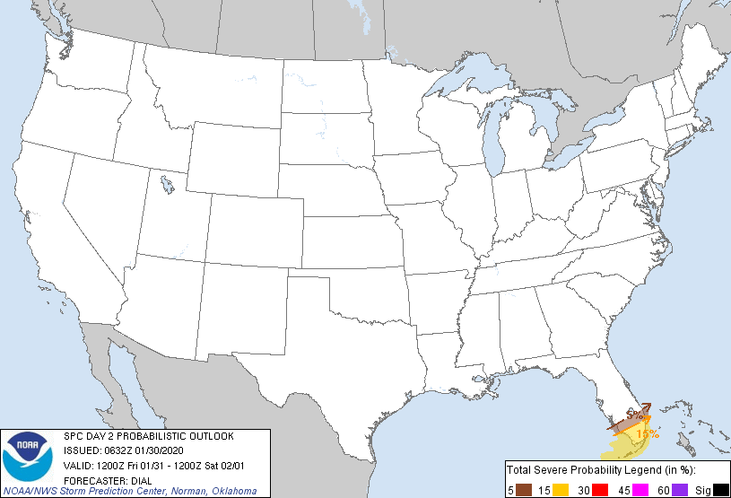
As the front marches eastward, this area will move east. The front will bring very strong winds just off the ground and any storm that can gain some elevation can tap into these winds and mix them down to the surface. This will have to be watched to see how the severe weather plays out today and what that can lead to in 24 hours. SPC sees the threat for tomorrow, but not as pronounced. This may increase depending on how today's events go:

Once this storm pushes through, it will usher in cooler air once again. From there, hopefully we can get some kind of calibration to our winter and allow for some snow to make its way into the snow starved areas in NJ.
Severe Weather Potential:



As the front marches eastward, this area will move east. The front will bring very strong winds just off the ground and any storm that can gain some elevation can tap into these winds and mix them down to the surface. This will have to be watched to see how the severe weather plays out today and what that can lead to in 24 hours. SPC sees the threat for tomorrow, but not as pronounced. This may increase depending on how today's events go:
Once this storm pushes through, it will usher in cooler air once again. From there, hopefully we can get some kind of calibration to our winter and allow for some snow to make its way into the snow starved areas in NJ.
Subscribe to:
Posts (Atom)