I am finally back up and running. My thoughts go out to everyone effected. Some were lucky, others not so much. We have all seen the devastation, and many of us are still speechless. The images out there and the ones still to come will take our breath away. For those who have lost loved ones, our hearts weep for you, and I send my sincerest condolences. Houses, cars, roads and power can all be replaced and repaired. The loss of a loved cannot.
My goal for my blog is to bring you information. Sometimes storms are fun and exciting and trust me, no one likes a good storm more than me. Other times, they can downright deadly. It's these deadly storms that change lives and our way of thinking. I can only hope my information can be used as a means of preparation. Mother nature doesn't always bring rainbows. Sometimes though, when we experience the worst mother nature throws at us, it brings out the best in people. We all have examples we can think of, and these are the things that matter most. Remember those who are still in need.
I would like to thank all my new followers, and those that have been with me for a while. I will continue to post on here, so please continue to share my page. Please continue to think of those who have had their lives turned upside down, I know I will be.
Tuesday, October 30, 2012
Saturday, October 27, 2012
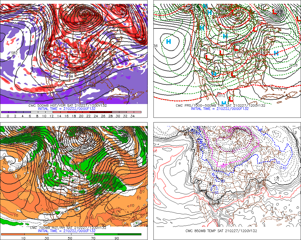
Sandy Evening Update 10/27/2012
You know what really grinds my gears?
Not much more to add from my previous posts, but I am going to re-emphasize a point I have made before. I explained how Sandy was initially a tropical Hurricane. A tropical hurricane is made up 100% of tropical characteristics. We knew at some point this was going to phase and become a hybrid storm, or simply not a 100% tropical storm anymore. Once it is no longer a 100% tropical, it becomes what is known as sub-tropical or post tropical. And, once it becomes subtropical, the National Hurricane Center will no longer issue warnings / watches etc. It was also decided this morning that they would not extend warnings or watches past North Carolina. Hence, why we have yet to be placed in a watch or warning yet. Instead, the NHC is punting the football to the local National Weather offices to make the calls.
Whats the big deal you ask? Well, up until this point things have progressed smoothly, and one agency was spearheading a consistent alerting method dealing with watches, warnings and discussions. Now, when the proverbial crap is going to hit the fan, they wash their hands of it and leave the coordinating up to 5 or 6 offices who are going to come up with their own watches and warnings and coming up with their own discussions. Not to mention, now they are going to have to take the time to coordinate communications with those other offices to make sure they are putting out a consistent message. And, since it is technically a subtropical system, the wording Hurricane Watch and Warnings will not be used. Instead, we will get High Wind Warnings, or Coastal Flood Warnings or a myriad of other things. This simple task is going to confuse the general public, and in a time like this, could mean peoples safety.
Case in point, Mayor Bloomberg had been talking about evacuations and such all week. Tonight, he had a press conference and actually stated that they are not concerned about storm surge because it is not like a tropical storm or hurricane. When I heard this, I really felt like growing my hair back so I could pull it out. #1, the storm surge from "still hurricane but soon to be subtropical" Sandy is going to out perform Irene, and numerous other "tropical storms" or "hurricanes" that have proceeded it. #2, there has never been a history of this type of storm coming north and making a hard left turn towards land. We simply dont know what kind of effect this will have on storm surge on top of an impressive forecasted surge. #3, the public is now confused, and when we are facing a storm of this magnitude, confusion is not your friend.#4, the general public has heard about tropical storm and hurricane Sandy ALL WEEK. now, all the sudden a day before it hits, we dont issue hurricane watches or warnings and people see high wind warning.....they will think it somehow has weakened, went out to sea, or will hit less than forecasted.
I am going to set the record straight. We are facing an unprecedented storm. We really dont know whats going to happen when this phase occurs and a massive storm suddenly hangs a hard left and comes ashore. We can see that there is a crapload of rain forecasted, and a hell of a lot of wind. Flooding will occur, power will be lost and damage will be caused. Where? All over....this is a massive storm, with a massive wind field and a massive amount of rain (and snow for those in WVA, E KY, W PA W VA). I really cannot be more clear. Heed the warnings, whatever they are, heed them. If your working, prepare to stay at work. If your at home, prepare to stay at home. Hopefully you have prepped the best you can.
Sorry, had to get this off my chest.
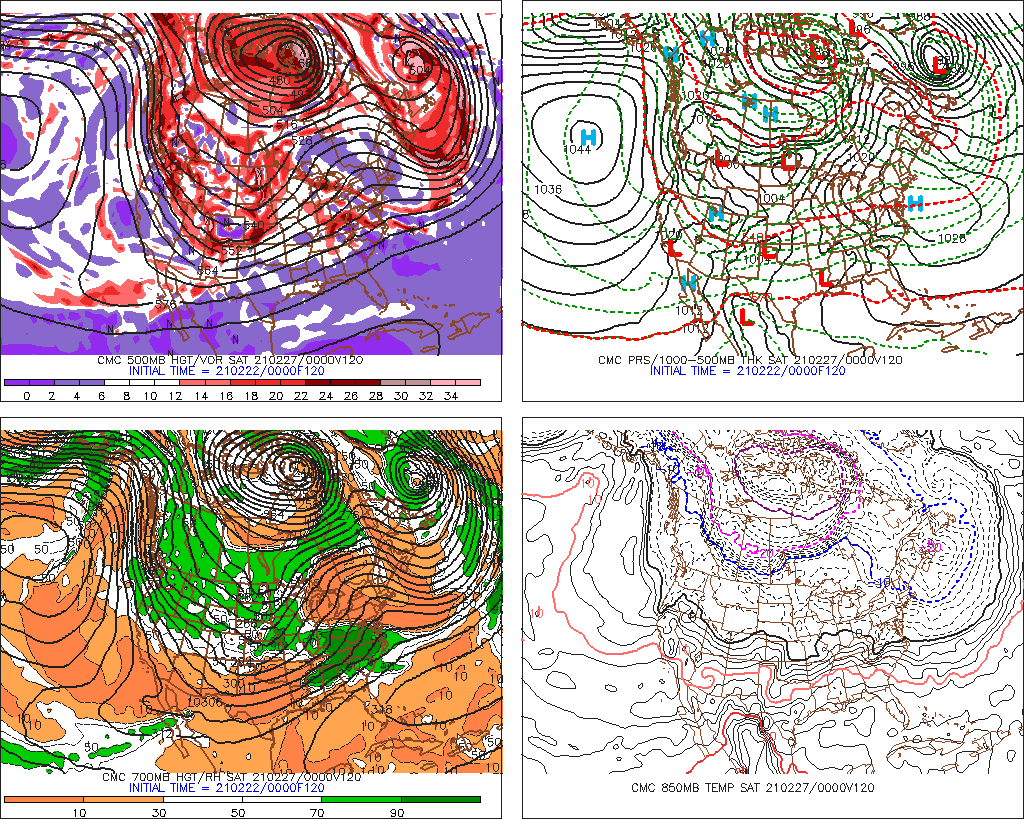
Sandy Morning Update 10/27/2012
for a brief 6 hour period last night, Sandy was dropped to a Tropical Storm. As of 8am though, she has regained hurricane strength. I explained last night that hurricane status is irrelevant really because this will be a dynamically driven storm that will feature a phase with the arctic jet. This phase will allow for rapid intensification prior to landfall.
I can say now with pretty good certainty that NJ is the odds on choice for landfall. This storm is going to be a very wide, very powerful storm. Regardless of where it hits, this will have far reaching devastation. As Sandy moves on land, areas to the north (Long Island, Southern New Englad) are going to experience winds sustained of 50-70mph with rains. Areas to the south of landfall will receive the heaviest rains (upwards of 1 foot....12 inches) and have winds sustained 30-50mph. All indications that I have seen on the models show an event bordering on 2 days......48 hours.
Sandy is crawling now off the SE US coast and is actually undergoing some changes to her structure. This is the reason for the change in status....and yes, this change was shown on the models. Everything at this point has pretty good agreement.
We cannot stop the weather, but you can prepare. Today is the day for that. While preparing, please remember you local liquor stores, they do have plenty of items to help you through the next couple of days, and I am sure they could use the extra business :)
More to come. Thank you again to all the people who have liked my facebook and twitter feed. Updates will be flying out through both over the next few days (as long as I have power).
@townerswxpage (twitter)
Towner's Weather PAGE (facebook)
Friday, October 26, 2012
Hurricane Sandy Evening Update 10/26/2012
Hurricane Sandy is still a category 1 Hurricane with sustained winds. This is a minimal hurricane at this point. it is expected to stay at this strength, or at Tropical Storm Strength for up to another 36 hours. From that point, it will begin to strengthen once again. With that being said, let me say this....do not go by the strength of the hurricane. This was never about the strength of the hurricane. The whole dynamic of the system is going to be when the phase takes place and draws the storm towards the coast. This is when the fireworks pop. Please oh please do not go by the strength of the hurricane and base the entire storm off of that.
major models are still keying in on our area. We are still under the gun for extremely heavy rains, strong winds and flooding.
More updates will be out again after the model runs tonight. Stay tuned to twitter (@townerswxpage) and my facebook page (Towner's Weather PAGE).
Hurricane Sandy Morning Update 10/26/2012
Hurricane Sandy is a Category 1 Hurricane with sustained winds at 80mph. She is sitting in the Atlantic due east of Miami, Fla. She is moving NW at 10mph. Here is the latest track:


There is a general consensus now that there will be landfall from Delaware to Long Island. I am fairly confident we will see landfall in that area as of now. One thing that I am going to say, DO NOT GET CAUGHT UP in what category hurricane Sandy is. This is not your typical hurricane, and will not behave as such. I say this because some of the characteristics that she will be taking on before landfall will not be Hurricane characteristics. Sure, a category 1 is better than a 3, but this is a very unique situation. Sandy is going to Phase with an impulse coming down from Canada and that will further enhance Sandy. When this phase happens, it will no longer be a tropical system. it will be known as a Subtropical system, and the phasing will greatly enhance the strength of the storm. This is be a VERY large area that will be effected, and it will really not matter where landfall is, we will be effected.
The phase is also whats going to draw Sandy back to the coast. Where exactly the phase starts will determine the landfall. This aspect will probably be unknown and will have to be "nowcasted" instead of forecasted. What to expect. Lots of rain, damaging winds, flooding, widespread power outages and possible torandoes (likely on the right side of the storm).
Here is the estimated rain amounts graph: This will be updated as we come closer too (I beleive that is 12.8 going into Delaware)-
In any case,there will be plenty more updates coming through. Remember to follow my twitter (@townerswxpage) and my facebook page (Towner's Weather PAGE).
Thursday, October 25, 2012
National Hurricane Center and HPC Not Messing Around
Wow, VERY bold. The National Hurricane Center just put this out with their 11am update:

PRELIMINARY EXTENDED FORECAST DISCUSSION
NWS HYDROMETEOROLOGICAL PREDICTION CENTER COLLEGE PARK MD
942 AM EDT THU OCT 25 2012
VALID 12Z MON OCT 29 2012 - 12Z THU NOV 01 2012
...HIGH IMPACT MERGING OF ENERGETIC SYSTEMS ANTICIPATED OFF THE
MID ATLANTIC COAST...
PRELIMINARY UPDATE...
DESPITE A MODEST CLUSTER OF OUTLYING DETERMINISTIC SOLUTIONS AND
ENSEMBLE MEMBERS FROM THE VARIOUS MODELING CENTERS, THE LION'S
SHARE OF GUIDANCE INDICATES THAT THE CIRCULATION ASSOCIATED WITH
HURRICANE SANDY WILL PASS CLOSE ENOUGH TO THE AMPLIFYING POLAR
TROUGH OVER THE EASTERN UNITED STATES TO BECOME INCORPORATED INTO
A HYBRID VORTEX OVER THE MID ATLANTIC AND NORTHEAST NEXT TUESDAY.
THE HIGH DEGREE OF BLOCKING FROM EASTERN NORTH AMERICA ACROSS THE
ENTIRE ATLANTIC BASIN IS EXPECTED TO ALLOW THIS UNUSUAL MERGER TO
TAKE PLACE, AND ONCE THE COMBINED GYRE MATERIALIZES, IT SHOULD
SETTLE BACK TOWARD THE INTERIOR NORTHEAST THROUGH HALLOWEEN,
INVITING PERHAPS A GHOULISH NICKNAME FOR THE CYCLONE ALONG THE
LINES OF "FRANKENSTORM", AN ALLUSION TO MARY SHELLEY'S GOTHIC
CREATURE OF SYNTHESIZED ELEMENTS.
Halloween / Sandy Morning Update 10/25/2012
Wow, woke up this morning to hear that Sandy overnight strengthened to a extremely strong Cat 2 Hurricane. At the NHC 2am update, Sandy had sustained winds of 110mph. Thats 1mph short of being a Cat 3 hurricane. Once we are talking about a cat 3 or higher hurricane, it is classified as a MAJOR hurricane. I had read somewhere yesterday that two days ago, they gave Sandy about a 1% chance of reaching cat 3 status. As of 5am, her winds went down to 105mph sustained. But, she is now clearing Cuba and will be back over water. The next 24 hours will be telling. A major hurricane is quite a feat. In any case, here is the latest on Sandy:


A beaut:
Now, to the models. The Euro stays steadfast. Still shows a bomb making landfall in Deleware / South Jersey. This is the 8th run in a row of a fairly consistent landfall. Here is the model:
MONDAY EARLY MORNING:
TUESDAY EARLY MORNING:
The NOGAPS gives a similar outcome although a little bit earlier:
Sunday Evening:
Monday Morning:
And the Canadian Model shows a similar track, but does not have the "phase" until it hits Long Island and then brings it back west across NYC (and this is Tuesday Morning):
Tuesday Evening:
The GFS model continues to bounce around from its out to sea solution, to a landfall in Maine and moves back west across Northern New England. As of the morning run, it was showing a further west track (for this model) and brings Sandy up to Maine before a phase occurs and brings it back over land:
Wednesday Morning:
6hours later:
So, there still is some spread. What we do know is there is an immense amount of variables that are going into this system. There is a lot that can go wrong and the timing needs to be perfect. A delay here, or something is not as strong as modeled can play a big part in a different solution. I will also say though, the closer we get, the chances increase of accuracy. Also, the National Weather Service will be performing increased weather balloon launching for each model update starting today. This will aid in getting the most up to date upper atmosphere conditions to be inputted into model guidance.
For Jersey (or any area really) the strongest part of a hurricane is the right front quadrant then the right lower quadrant. These areas have the highest storm surge, heaviest rain, strongest winds and also the area that produces most of the severe weather (tornadoes, hail). This would be the impact for Jersey with a EURO or NOGAPS hit. The Right lower quadrant is the second strongest part, followed by the left front quadrant (Canadian Model scenario) and then the left lower quadrant is typically the weakest. This is another aspect of the storm that will have to be followed. You can imagine if we have a storm surge of 10-15 feet of water moving up the Delaware Bay into the Delaware River.
Anyways, more to come. Please stay tuned.
I will be updating both my twitter account (@townerswxpage) and facebook (Towner's Weather PAGE)
Wednesday, October 24, 2012
Sandy Update Evening 10/24/2012
Well, Sandy has passed through Jamaica and is now poised to hit Cuba. Sandy has intensified and now has winds up to 85 mph. In the latest Hurricane Hunter recon flights into the storm, they have measured winds up to 90 mph. Once 94 mph sustained winds are found, Sandy will become a Category 2 Hurricane. Very impressive to say the least because a day ago, Sandy was not supposed to become a hurricane until tonight, hence a borderline cat 2 storm. Very impressive to say the least.


Halloween / Sandy Update Midday 10/24/2012
Oh boy, lots of news now.
First things first, Sandy is now a hurricane. Sandy is packing 80mph winds and is currently making landfall in Jamaica. She will move up and through Cuba tonight and then take aim at the Bahamas Thursday Night into Friday. From there is where the real fun will begin. Here is the projected track as of 11am today:


First things first, Sandy is now a hurricane. Sandy is packing 80mph winds and is currently making landfall in Jamaica. She will move up and through Cuba tonight and then take aim at the Bahamas Thursday Night into Friday. From there is where the real fun will begin. Here is the projected track as of 11am today:
Now, on this page, you can already see that this track is further west then it has been over the past couple days. I have already talked about the impulse in the area of Alaska that will cause the ridging out west (which creates the trough in the east). The trough in the east will allow the storm to ride along it, and eventually phase in with the arctic jet. When this phase occurs, this will be the driving force to "pulling" the storm westward to the coast.
The Euro model has been deadly consistent over the past three days (6 model runs) of showing very consistent outcomes. it has been showing a monster hit in the area (all bringing a bad scenario to those of us in Jersey.) last nights run was probably the worst run Jersey could potentially experience with this storm.) It brought Sandy up the east coast, effecting the major cities and then when the phase took place, Sandy made an immediate left turn into Jersey. Here is the model run showing the scenario:
Monday Early Morning:
Tuesday Early Morning: (making left into Jersey)
And finally, Wednesday morning, over Philly:
no need to explain the outcome here, it would be devastating. strong winds, massive amounts of rain, widespread power outages etc etc. The Euro has been showing an East Coast impact for like I said, 3 straight days (6 model runs). Its on to something.
I have talked a lot about the GFS model and how 4 days ago, it showed a similar hit, only to take it out to sea and bother Bermuda. Over the past three days, it has taken small steps back towards the Euro solution. It has tried to show what would happen if Sandy was not able to phase, and the ridge out west was not as strong, and a progressive pattern would just let the storm escape out to sea. The scary part is, over the past couple days, the model has begun to recognize all the players on the field. This is why a move towards the EURO solution is troublesome because now it really enforces the idea this can happen. So, todays midday run of the GFS model has brought the storm back to effecting the east coast, and actually makes landfall in Maine. So, we can see it is recognizing the players, and adjusting accordingly. I believe it will continue to do this and move towards the EURO.
When a model runs, it is made up of a number of subsets that take into account a number of different variables. These ensemble runs make up the operational run. the operational run is kind of a medium of all the ensemble members of the model. Well, whats interesting is, over the past few days, we had a large majority of the ensemble members taking the track well off shore and out to sea. Over the past few days, many of the ensemble members have began to switch over to a more coastal track. Each run, the more members went further west to where we are now. Even as this operational run of the GFS took Sandy to Maine, many of the ensemble members are continuing to show a more westward track. For this reason, I am not going to be shocked to again think that this will move even further west.
So, bottom line, models are really starting to show the real potential here with a devastating storm that is taking aim on the east coast. There will be plenty more updates to come. Please continue to monitor the National Weather Service for further updates. i will also be passing all those along and then some on both my twitter (@townerswxpage) and on my facebook page (Towners Weather PAGE). Please share with friends and let them know. I try and keep updates throughout the day and let you know things as soon as I do.
Tuesday, October 23, 2012
Halloween / Sandy Update
Ok, so some recap here for the morning. We have Tropical Storm Sandy south of Jamaica. Sandy is currently packing 45 mph sustained winds. Sandy is probed to become a Hurricane Wednesday Night into Thursday, before making landfall in Jamaica. Sandy is entering into very favorable conditions for strengthening. here is the morning update from the National Hurricane Center:

So, from here, Sandy will move across Jamaica, Cuba and then through the Bahamas. From there is when we will really have to start watching what happens. I explained the first part of the puzzle yesterday was solved when Sandy was born. We will now have to monitor weather modeling. Some of the things I will be looking at is the Gulf of Alaska. Here is a key feature that will determine, ultimately, if Sandy will be able to head up the coast or if she moves off shore. If we can get this disturbance to be on the stronger side, it will create a ridge in the west, which means a trough in the east which will allow Sandy to move up the coast and phase with the Arctic jet. If the disturbance in the GOA is weaker, it will keep the ridge more progressive and flat, essentially allowing Sandy to move off shore and threaten Bermuda.
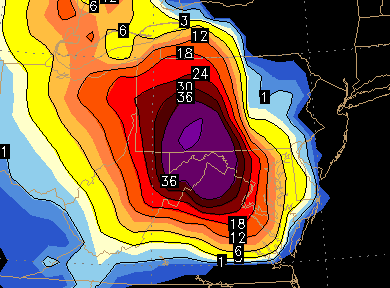
From there, assuming we can get a stronger impulse in the GOA, we will then have to take a look at blocking downstream which would prevent Sandy from escaping East and slow her down. From there, we would then have to see how she would interact with the Arctic and Polar jets as far as a phase could go. In any case, its going to be a wild ride. Euro model still showing a monster, indications of the GFS model maybe wavering a bit westward and the Canadian Model still showing a bomb. FYI too, just so you know what kind of system we are dealing with, the Euro model also drops 36" of SNOW in Western PA!!!! Not saying that is going to happen, but this has the potential to be a very dynamic and powerful storm. Here is the snow graphic from last nights' Euro model:
Monday, October 22, 2012
Halloween Update Midday 10/22/2012
The first part of the equation has been solved, we now have Tropical Depression 18. TD 18 is located south of Jamaica and will slowly move to the north. This is poised to become a Tropical Storm, and would take on the name Sandy. This is the first of many pieces of a puzzle to potentially come together to bring us a rather potent storm.
TD 18 graphic:

TD 18 graphic:
Halloween Update
I started talking about a potential storm for next week last night. The evening run of the GFS was the first to show a further east solution, which it still has, but the EURO model has remained fairly consistent with its track. Here is the morning update. Euro still shows a major storm, and the GFS is out to sea.
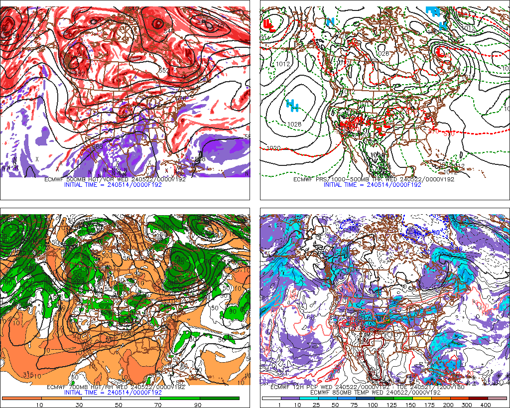
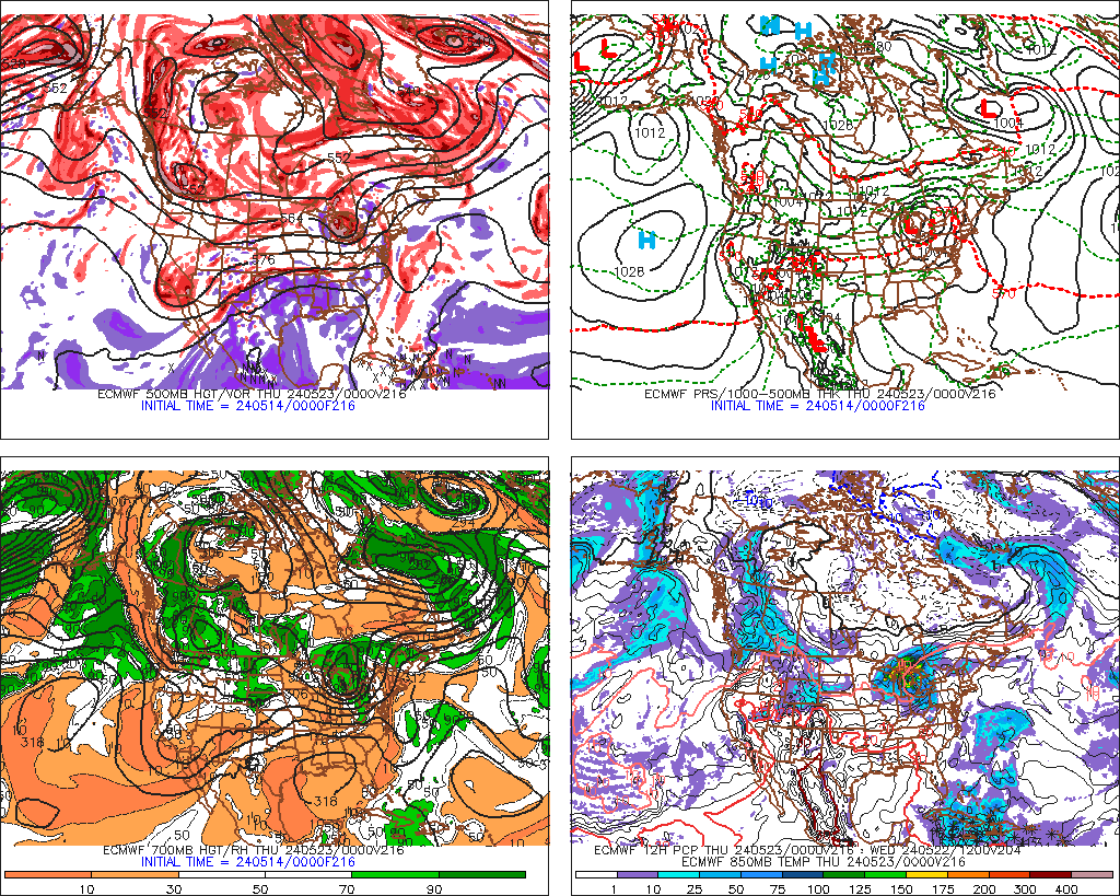
Here is the midnight run of the EURO at 192hrs:
and 216 hrs:
one thing about this run, it shows a large storm, and really brings down some cold air all the way down to the Gulf States.
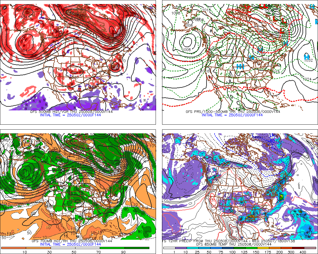
The GFS model, depicted here at 144 hrs has the storm, but then moves it East and out to sea:
more to come.
Sunday, October 21, 2012
Trick Or Treat
Well, its a little early, but we have a storm to track. This morning, some weather models were hinting at a significant east coast storm towards the end of the month. Then, the midday runs had all the major models jumping on board, and surprisingly a strong agreement in track up to about 120 hours. The beginnings of this is a disturbance now, south of Jamaica. This storm has a high likelihood of developing into a tropical cyclone over the next couple days (tropical storm / hurricane). As this moves north, it is going to interact with the subtropical jet stream arctic jet and the polar jet streams setting up the potential for a significant to severe weather situation along the east coast ( a perfect storm? triple phaser?). Like i said, all models had some semblance of this at the midday run.
So, what does this all mean....well, obviously, the potential is there for a significant storm. We are days away and for now, we need to watch this and see how things unfold. The Euro model has this coming in around the 29th, while the GFS model has this around Halloween. This would take a immense amount of variables to come together to produce this. Anyways, keep your guard up, pay attention and follow me on facebook (Towners Weather Page) and twitter (@townerswxpage).
Here are variables and model runs:
Disturbance (number 1):

GFS Midday Run: 204 hours
 EURO Model Run 180 hours

And for good measure, a snow map out to 384 hours on the GFS (includes this storm)
 More to come....
So, what does this all mean....well, obviously, the potential is there for a significant storm. We are days away and for now, we need to watch this and see how things unfold. The Euro model has this coming in around the 29th, while the GFS model has this around Halloween. This would take a immense amount of variables to come together to produce this. Anyways, keep your guard up, pay attention and follow me on facebook (Towners Weather Page) and twitter (@townerswxpage).
Here are variables and model runs:
Disturbance (number 1):
GFS Midday Run: 204 hours


And for good measure, a snow map out to 384 hours on the GFS (includes this storm)
Subscribe to:
Posts (Atom)