Well, here we are. Back to tracking exciting snowstorms! This one actually has me pretty excited. Not only at the potential snow impact, but for the fact that following the storm, we are looking at the coldest temperatures in the area since 1994. I am trying to think back that far, and think I can remember that. If my memory serves correct, we had an snow to rain event that was followed by a very powerful cold front that dropped many areas to near zero and highs were only in the single digits to teens. I can remember it well because we had about 8-10" of snow, followed by a period of heavy rain and then everything froze. We were able to ride our bikes across the top of the snow. We had a blast for a week (we were out of school for the week because of the temperatures). These are temps expected (from the EURO model) for Saturday Night (during the Eagles game)
So, its going to get cold after some snow....but how much? Well, thats the question. We have a pretty dynamic storm setting up, with a lot of moving pieces. While the models have been hinting at the potential storm for some time, we are now getting closer to a point where the models are able to ingest much better data. For our storms, data is best taken when the pieces of the storm come closer to the United States. Obviously, that is where we have all of our sensors, observers, weather balloons, etc. We are getting to that period tonight and tomorrow morning.
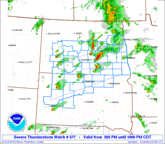
You may hear the terms Miller A and Miller B storms over the course of the week. This will be the type of storm we will be dealing with. Either, the storm will be coming out of the Gulf of Mexico and up the coast (Miller A) or will be diving into Ohio and then redeveloping along the East Coast (Miller B). Its unclear at this time which type we will be dealing with, but both can have significant impacts for our area. Miller A storms tend to affect a larger area ( entire east coast) while the Miller B storms will only impact those areas where redevelopment takes place and north. Both are capable of delivering a very big punch. Obviously, track, type, timing, etc will all play crucial factors to the final outcome. For now, I am expecting a plowable snow event (greater than 3") for the area. This will be for the period Thursday thru Friday. As models continue to evolve to a solution, I will continually update. The GFS and Euro models have both shown significant storms this afternoon. However, I am going to wait to see if they can get some consistency over the next few model runs. Until then, we are looking at a potential storm. Potential or not, this one has me pretty excited! Buckle Up!
Special Weather Statement (New Jersey) 2013-12-24T16:46:00GMT-0500 2013-12-24T20:15:00GMT-0500BETWEEN NOW AND 800 PM, SCATTERED SNOW SHOWERS WILL MOVE ACROSS THE PHILADELPHIA METROPOLITAN AREA, PARTS OF CENTRAL NEW JERSEY. NORTHEAST MARYLAND AND NORTHERN AND CENTRAL DELAWARE. SOME LOCATIONS MAY PICK UP A DUSTING OF SNOW ON GRASSY SURFACES. IF YOU WILL BE DRIVING THIS EVENING, BE PREPARED FOR BRIEFLY REDUCED VISIBILITY. Camden; Gloucester; Northwestern Burlington; SalemThis NWS weather information is brought to you by Weather Alert USA for the iPhone
No major changes on the model runs today. Snow spreads into the region between 4-7am and will likely be out of the area come early afternoon. No real major changes to the accumulations. Shore areas may start as snow, but likely will change over to rain rather quickly with no accumulation. I am liking 1-2" for essentially the lower half of Jersey (South of Burlington / Ocean Counties) in areas where it snows. Northern Jersey (North of Mercer/Monmouth) could see 2-4".
There is also some modeling that is showing another wave moving through tomorrow night for the southern half of NJ. This could potentially drop another coating up to 1" for some areas if it materializes.
Also, another thing I cannot rule out is the fact that Clippers often times come in moisture starved and can really under perform. Our best accumulations come from a Clipper that moves in, hits the ocean and intensifies, dropping measurable snowfalls. This will not be the case with this system. This will be a quick moving system and with no blocking downstream, it will fly through. So, that's another thing I will be watching.
For those of you who do not like snow, in 36 hours our temperatures will be moderating to more normal temperatures. Then, this weekend, we will be looking at highs in the 50's. In addition, winter officially starts this weekend. Colder temperatures will return around the Christmas time.
Winter Weather Advisory (New Jersey) 2013-12-16T14:56:00GMT-0500 2013-12-17T16:00:00GMT-0500A WINTER WEATHER ADVISORY MEANS THAT PERIODS OF SNOW...SLEET...OR FREEZING RAIN WILL CAUSE TRAVEL DIFFICULTIES. BE PREPARED FOR SLIPPERY ROADS AND LIMITED VISIBILITIES...AND USE CAUTION WHILE DRIVING. ...WINTERS EMPHATIC DECEMBER START WITH BELOW NORMAL COLD AND FREQUENT SNOWS WILL CONTINUE WITH A QUICK HITTING SNOW EVENT TUESDAY MORNING...
.HAZARDOUS TRAVEL WILL DEVELOP DURING THE TUESDAY MORNING COMMUTE AS LOW PRESSURE NOW OVER THE OHIO VALLEY REFORMS SOUTH OF LONG ISLAND ON TUESDAY.
...WINTER WEATHER ADVISORY IN EFFECT FROM 6 AM TO 4 PM EST TUESDAY...
THE NATIONAL WEATHER SERVICE IN MOUNT HOLLY HAS ISSUED A WINTER WEATHER ADVISORY FOR SNOW...WHICH IS IN EFFECT FROM 6 AM TO 4 PM EST TUESDAY. * LOCATIONS...NEAR THE INTERSTATE 95 CORRIDOR FROM PHILADELPHIA AND ITS NEARBY SUBURBS TO NEW BRUNSWICK NEW JERSEY INCLUSIVE OF ALL OF CENTRAL NEW JERSEY TO THE COAST. * SNOW ACCUMULATIONS...ONE TO 2 INCHES OF SNOW IS EXPECTED DURING THE MORNING. LEFTOVER ADDITIONAL ACCUMULATION IS POSSIBLE DURING THE AFTERNOON IN EAST CENTRAL AND COASTAL NORTHEAST NEW JERSEY... PARTICULARLY MIDDLESEX AND MONMOUTH COUNTIES WHERE ISOLATED 3 OR 4 INCH STORM TOTALS MAY OCCUR. * TIMING...SNOW WILL DEVELOP BETWEEN 5 AM AND 7 AM AND END FROM WEST TO EAST BETWEEN 1 PM AND 4 PM. * WINDS...WILL BE LIGHT. * IMPACTS...SNOW WILL BE FALLING DURING THE MORNING COMMUTE WITH TEMPERATURES MAINLY IN THE MID TO UPPER 20S. ALL UNTREATED SURFACES WILL BE SLIPPERY AND HAZARDOUS. PLAN ON MORNING TRAVEL DELAYS AND LEAVE EARLIER TO REACH YOUR DESTINATION ON TIME. TRAVEL CONDITIONS SHOULD IMPROVE CONSIDERABLY TUESDAY AFTERNOON AS THE SNOW TAPERS OFF AND TEMPERATURES RISE ABOVE FREEZING. Camden; Eastern Monmouth; Mercer; Middlesex; Northwestern Burlington; Ocean; Somerset; Southeastern Burlington; Western MonmouthThis NWS weather information is brought to you by Weather Alert USA for the iPhone
All models are showing a clipper moving into the area tomorrow morning bringing another round of snow for the area. This will be primarily an accumulating snow for areas north of S NJ - Philly line. Our area can expect probably on the order of 1-3" with 1" being in the lower areas and more as you go north. Areas north of Newark into the Lower Hudson Valley and CT could potentially be looking at 2-4". This will be another quick moving storm. Precipitation breaks out over the morning hours, and will wrap up during the afternoon.
Interesting tidbit on the noontime NAM model run, still has a little area that pops up tomorrow night as a second wave moves in, which focuses precipitation over S NJ. They could possible pick up another 1-2" down there assuming temperatures cooperate.
Once this passes through, temperatures will moderate through the rest of the week. Towards the end of the week and the weekend, we may have highs into the 50's over the C NJ area. Temperatures do look to once again get colder around Christmas.
On the heels of a very good week for the snow lovers, we begin this week with a clipper threat heading our way for Tuesday. This will once again be a quick hitting storm, but will drop some accumulating snow in our area. Snow looks to move in during the late morning hours and then will be out by the evening. Models are also showing another disturbance that may move in overnight Tuesday and bring some more snow showers to the area. Generally speaking, this event will be a E PA, NJ, S NY up through the Northeast. More to come on this! Generally looking at a 1-3" / 2-4" type event.
So, I have stressed over the past two days about tight gradients. Today, models continued to show that in our area, 40 miles can really make the difference between no accumulations and quite possibly 6-10". We could really see something like Southern Bucks Co, PA with 2" while Northern Bucks County is getting 8" I cannot stress enough how close this will be. There will be some things that will be nowcasted tomorrow that could change things as well. I will be updating frequently throughout the day on facebook and twitter.
Some of the things I will be looking at tomorrow:
1. Miller B type storms (which this is) usually leads to some type of "dry slot". This is an area where there is a break in precipitation. When and where this happens will obviously have an effect.
2. Placement of high pressure in Canada (directly north of us). If it is closer to the Canada/US border, we could see the cold air hold on longer. If it migrates up to Quebec or farther north, we may have an earlier transition to sleet
3. Any banding that develops that can enhance snowfall totals.
4. Where the primary low pressure dies and where the new one takes over. Either of these things can also effect our area
In any case, on to amounts.
coastal areas of NJ, I am expecting an almost all rain event. Possibly some snow to start, but quickly to rain
inland from there, SNJ East of the NJ TP up to 195 I expect 1-3" then rain
PHL - Trenton - West of the NJTP 1-3" before turning over to a bit of sleet and then rain
just to the NW of PHL - Trenton- New Brunswick - Newark, NJ 3-6" mix then rain late
Areas of the Lehigh Valley, C PA , NW NJ, Lower Hudson Valley through S CT 6-10"
Central and Northern CT through MASS up through VT, NH and Maine generally 10-14"
These are my thoughts at this time. Tomorrow will be a nowcasting day and any changes can lead to significant changes.
Mercer/Middlesex south gets the advisory, north of that, warnings are in effect. This is going to be a tight gradient, 40 miles can seperate 10" of snow.
Winter Weather Advisory (New Jersey) 2013-12-13T15:24:00GMT-0500 2013-12-14T17:00:00GMT-0500A WINTER WEATHER ADVISORY MEANS THAT PERIODS OF SNOW...SLEET...OR FREEZING RAIN WILL CAUSE TRAVEL DIFFICULTIES. BE PREPARED FOR SLIPPERY ROADS AND LIMITED VISIBILITIES...AND USE CAUTION WHILE DRIVING. ...A WINTER STORM AND HAZARDOUS TRAVEL WILL AFFECT THE WARNING AND ADVISORY AREA SATURDAY INTO EARLY SUNDAY MORNING...
.LOW PRESSURE OVER THE SOUTHERN PLAINS WILL MOVE TO THE NEW JERSEY COAST LATE SATURDAY NIGHT...THEN STRENGTHEN AS IT MOVES TO NOVA SCOTIA LATE SUNDAY. A WIDESPREAD SNOWFALL IS FORECAST...AND SIGNIFICANT ACCUMULATIONS ARE FORECAST. WARMER AIR NEAR THE PATH OF THE STORM CENTER SHOULD ARRIVE SATURDAY NIGHT... RESULTING IN SLEET AND OR FREEZING RAIN IN THE INTERIOR...ESPECIALLY ACROSS PORTIONS OF SOUTHEASTERN PENNSYLVANIA... WESTERN AND NORTH CENTRAL SECTIONS OF NEW JERSEY.
...WINTER WEATHER ADVISORY IN EFFECT FROM 7 AM TO 5 PM EST SATURDAY...
THE NATIONAL WEATHER SERVICE IN MOUNT HOLLY HAS ISSUED A WINTER WEATHER ADVISORY FOR SNOW CHANGING TO A PERIOD OF SLEET SATURDAY AFTERNOON...WHICH IS IN EFFECT FROM 7 AM TO 5 PM EST SATURDAY. * LOCATIONS...NORTHERN DELAWARE THROUGH PORTIONS OF SOUTHWEST AND NORTHEAST NEW JERSEY NEAR AND JUST EAST OF INTERSTATE 95. * ACCUMULATIONS...SNOW ACCUMULATION OF 1 TO 3 INCHES...ALONG WITH A LITTLE SLEET BEFORE CHANGING OVER TO RAIN LATE IN THE DAY. * TIMING...SNOW BEGINNING SOMETIME SATURDAY MORNING. SNOW MAY BE BRIEFLY HEAVY FOR A TIME DURING MID OR LATE AFTERNOON BEFORE CHANGING TO SLEET AND THEN RAIN. * TEMPERATURES...RISING IN THE MID 30S BY LATE IN THE DAY. * IMPACTS...INTERMITTENT PERIODS OF HAZARDOUS TRAVEL EXPECTED. Camden; Gloucester; Northwestern Burlington; Salem; Western MonmouthThis NWS weather information is brought to you by Weather Alert USA for the iPhone
Well, the nighttime model runs are in and......... they paint a MUCH colder scenario. While this scenario is nice to see, it is really a thread the needle type of situation. There is a MASSIVE gradient over about 40 miles from nothing along the coast to 8" along the Delaware River. And while I am in no way calling for that much snow anywhere near this area, it cannot be discounted. A shift in any amount one way or the other can lead to drastically different outcomes.
So, for now, lets take it with a grain of salt. For now, know that this storm will start out as snow Saturday morning. We will more than likely receive an accumulating snow. I still believe that we transition to a mix and then rain, the question will be when. I am not jumping on the snow train yet after one model run, but it will be something to look forward to during the day tomorrow and tomorrow night.
I will be following tomorrow and will have my final thoughts on this tomorrow night.
The area will once again be looking at another storm moving in. This past week, many areas have eclipsed total snows from the last two years combined and we are looking at another storm adding to snow totals. We have a little different setup for this storm, which will make things interesting going into the weekend. We will have a low pressure system moving into the Ohio River Valley which will die off and transfer energy to a new low pressure along the coast. The big questions for our area will be, where does the initial low pressure die off, and where does the new low form. Having a low pressure to your west will spell temperature disaster if it holds on longer than projected, and likewise, if it dies earlier and the new low forms earlier, temperatures can be more favorable for snow. These storms have led to numerous issues that have happened before, and have both worked against us and for us.
As it is modeled now, it appears we will have a period of snow Saturday afternoon and evening before temperatures rise high enough to transition to mixed precipitation and then rain by early Sunday morning. We would be in for a couple inches of snow before the transition. Areas in NE PA, NW NJ, North of NYC and mid to northern area of CT will do very well with this storm. Its the areas south of those that will have the battles going on.
The NAM model has been the warmest of most models and keeps the low pressure tucked into the coastal region, while the EURO and GFS models keep the low pressure about 150-200 miles out into the ocean. The NAM would have a quicker transition to rain while the EURO and GFS will allow for a little more snow. I will be watching to see if any of those models begin to shift toward the other. In any case, all show a start of snow and a couple inch accumulation.
There will be more to come with this over the next two days, so stay tuned and enjoy the cold weather today and tomorrow!
Models today have continued the general theme of a snowy Tuesday for the PHL - NYC corridor. All guidance is showing a plowable event for the area. Another common theme among the models is the formation of a rather robust band of snow. While this band of snow is showing up on models, and will be a driving force to greater accumulations, it will be something that will have to be nowcasted tomorrow closer to the event. Where this band sets up will be the "winners" in the snow accumulation. As of now, this line is forecasted per guidance to setup over our area. This is the reason why the Delaware River locations from PHL to Trenton is in a warning and not an advisory like the rest of the area. Needless to say, it will have to be something that I will be watching tomorrow. While the forecast is saying 4-6" for the area, if we do not end up under the band, we will probably have advisory level snows (2-4"). After the snows from yesterday, we can see what kind of accumulations you can get under one of those bands. Wilmington, DE to PHL to Southern NJ had a broad area of 6-10" of snow under that band that broke out. The moral of the story here is, we will have a general area of 2-4" snows, but getting hit by one of the bands of snow will increase those amounts, and that will have to be nowcasted tomorrow. In any event, precipitation type should not be a question. It will be getting colder as the storm progresses (as another round of cold pushes in) so we are looking at a solid snow event. This will be the type of snow that will stick around through the night and cause travel headaches since it will be blowing around and minimal melting will take place (sans areas that are treated). Start time looks like mid to late morning through the area. It will start from the SW and move NE. It will be a quick hitter and more than likely be winding down by the evening.
Special Weather Statement (New Jersey) 2013-12-09T14:29:00GMT-0500 2013-12-09T16:30:00GMT-0500...PATCHY DENSE FOG FOR THE AFTERNOON AND THE START OF THE EVENING COMMUTE...
THE MOIST SOUTHWEST FLOW OVER THE SNOW PACK HAS PRODUCED AREAS OF FOG THAT IS DENSE IN SOME AREAS. VISIBILITIES IN SOME LOCATIONS ARE LESS THAN HALF A MILE. THIS IS ESPECIALLY TRUE NEAR OPEN FIELDS AND ON SOME HIGHER TERRAIN ROADWAYS. IF TRAVELING INTO THIS EVENING, PLEASE BE WARY OF CHANGING ROAD CONDITIONS. PLEASE USE LOW BEAMS WHILE DRIVING THROUGH THICKER PATCHES AND ALSO GIVE YOURSELF EXTRA BRAKING DISTANCE. PLEASE ALSO BE WARY FOR PEDESTRIANS, ESPECIALLY ONCE IT STARTS GETTING DARK. Camden; Gloucester; Hunterdon; Mercer; Middlesex; Morris; Northwestern Burlington; Somerset; Sussex; Warren
The C NJ area has now changed over to rain, bringing to a close the frozen precipitation aspect of the early season surprise. Many areas exceeded snowfall amounts, and areas not expected to receive snow got a nice surprise (unless you dislike snow). So, what happened? Well, for starters, the cold high pressure that had cold air over the region prior to the precipitation start was much more stubborn than modeled. The High pressure to the north did not budge, and the over-running warm air caused some mesoscale banding to set up with an area of very significant snows. Anyone watching the Eagles game yesterday saw first hand the tenacity of the falling snow. This part of the storm was not picked up by the major global models. Instead, it was picked up by the very short term HRRR model which had this nailed from Sunday morning. So, once again, models are not gospel and there is always room for now-casting events. Luckily, with warning systems, social media and other means, warnings can get out much faster for alerting citizens. In any case, many areas received 6"+ in the greater Philly area.
As this storm winds down, we turn our attention to Tuesday. Once again, a storm will move in bringing the area another chance at some snow. This storm will move in around noon and will be out of the area by late evening. It will be a quick hitter, but areas can generally look to pick up 2-4" with some areas getting a little more with any areas that get hit with a heavier snow band. This will have some impacts on the evening rush hour. Once this storm moves out, we will be entrenched into a cold pattern for the foreseeable future.
Our next shot at a storm will come this weekend, towards the end. The Euro model is showing a low pressure which will head to the east coast. Its movement from there is still unknown, but will be watched over the next couple of days.
Thanks for the many observations that were tweeted or facebooked. Feel free to send photos / tweets etc and I will retweet them or share them out to everyone!
Winter Storm Warning (New Jersey) 2013-12-08T12:41:00GMT-0500 2013-12-09T00:00:00GMT-0500A WINTER STORM WARNING MEANS SIGNIFICANT AMOUNTS OF SNOW... SLEET...AND ICE ARE EXPECTED OR OCCURRING. STRONG WINDS ARE ALSO POSSIBLE. THIS WILL MAKE TRAVEL VERY HAZARDOUS OR IMPOSSIBLE. ...WINTER STORM WARNING IN EFFECT UNTIL MIDNIGHT EST TONIGHT...
THE NATIONAL WEATHER SERVICE IN MOUNT HOLLY HAS ISSUED A WINTER STORM WARNING FOR SNOW, SLEET AND SOME FREEZING RAIN, WHICH IS IN EFFECT UNTIL MIDNIGHT EST TONIGHT. THE WINTER WEATHER ADVISORY IS NO LONGER IN EFFECT. * SNOW AND SLEET ACCUMULATIONS...3 TO 6 INCHES. * ICE ACCUMULATIONS...AROUND A TRACE. * TIMING...SNOW WILL OVERSPREAD THE AREA INTO THE EARLY AFTERNOON HOURS AND IT MAY BECOME HEAVY FOR A TIME. THE SNOW WILL MIX WITH SLEET DURING THE EVENING FROM SOUTHEAST TO NORTHWEST... THEN CHANGE TO RAIN DURING THE OVERNIGHT. THERE SHOULD SOME FREEZING RAIN FOR A BRIEF TIME DURING THE TRANSITION PERIOD THIS EVENING. * IMPACTS...SLIPPERY TRAVEL WILL DEVELOP ON UNTREATED ROADWAYS. BRIDGES AND OTHER ELEVATED SURFACES TEND TO ICE UP FIRST. * VISIBILITIES...BELOW 1/2 MILE AT TIMES. * TEMPERATURES...IN THE UPPER 20S TO AROUND 30 DEGREES. Camden; Gloucester; Northwestern Burlington; SalemThis NWS weather information is brought to you by Weather Alert USA for the iPhone
Special Weather Statement (New Jersey) 2013-12-08T10:28:00GMT-0500 2013-12-08T14:00:00GMT-0500...A PERIOD OF SNOW AND SLEET TO AFFECT THE AREA THIS AFTERNOON AND EVENING...
AN AREA OF MOISTURE WILL GRADUALLY OVERSPREAD THE AREA THROUGH THE REST OF THE DAY FROM SOUTH TO NORTH. THE COLD AIR CURRENTLY IN PLACE IS ANTICIPATED TO REMAIN FOR A WHILE RESULTING IN SNOW DEVELOPING. HOWEVER AS SOME MILDER AIR ARRIVES ABOVE THE SURFACE, THE SNOW WILL MIX WITH AND CHANGE TO SLEET TOWARD EVENING, STARTING FIRST FROM PHILADELPHIA ON SOUTH AND EAST AND THEN SPREADING NORTHWARD. AS SOME MILDER AIR GRADUALLY WORKS ITS WAY IN THIS EVENING, SNOW AND SLEET IS EXPECTED TO CHANGE TO RAIN INLAND WITH TIME. THERE IS A CHANCE THAT SOME FREEZING RAIN OCCURS FOR A BRIEF TIME DURING THE TRANSITION PERIOD. SNOW AND SLEET ACCUMULATIONS THROUGH EARLY THIS EVENING SHOULD BE A COATING TO AN INCH. IF TRAVELING THIS AFTERNOON AND THIS EVENING, BE PREPARED FOR DEVELOPING SLIPPERY CONDITIONS ON UNTREATED SURFACES AND CHANGING VISIBILITIES. REMEMBER, BRIDGES AND OTHER ELEVATED SURFACES TEND TO BECOME SLIPPERY FIRST DURING WINTRY PRECIPITATION. Camden; Gloucester; Mercer; Middlesex; Northwestern Burlington; Salem; SomersetThis NWS weather information is brought to you by Weather Alert USA for the iPhone
It appears the area will have its first winter weather event of the season. While I am not expecting much accumulation, it does appear rather likely that we will have some frozen precipitation. We have a rather cold airmass overhead now, and will have a storm moving into the area from the south. The big question with these events are how fast the warmer air of the northerly moving storm can overcome the cold air in place. Typically, with these types of storms, you will see precipitation to the south, but it will crawl on a northern advancement. This is due to the evaporational cooling in the upper atmosphere. Our cold airmass will take some time to saturate before precipitation starts to fall to the ground. Precipitation will start in the form of snow and will change over to sleet and freezing rain and then all rain.
As of now, I think the snow starts in South Jersey late morning and then into the PHL - Trenton corridor in the early afternoon. Places in Northern NJ may have to wait until evening time for the precipitation to start falling. I expect a coating in areas of Southern NJ (away from the coast) and a coating to as much as 2" around C NJ. My other thinking with these types of storms is that a changeover usually occurs prior to the modeled time. So, a quicker changeover would lead to lesser accumulations, but travel could be just as bad if not worse. I think S NJ goes over to rain by late afternoon, CNJ by evening and Northern NJ overnight. Eventually, the rain will encompass all areas and will quickly wash away any accumulations.
After this storm, we turn our attention to another round of precipitation on Tuesday and Wednesday. More to come on that after tomorrow.
While temperatures were fairly warm this morning, a cold front has pushed through. Temperatures have been steadily falling all day and will continue to do so. Meanwhile, precipitation is pushing into the area and may be around through early Saturday morning. The rain / snow line is currently around Mt. Pocono, PA and pushing SE. Will it make it down far enough to the area to perhaps see some frozen precipitation? We will have to watch and see how it moves over the next couple hours. I have a feeling we may see a bit. Areas in NW NJ will stand the best chances for a changeover. I am not expecting any accumulations down here.
Once this storm pushes out, all eyes will turn to Sunday. A lot of talk has been made about a significant ice storm. While this will be the case for C PA, C MD, WV, W VA, we will only start as frozen precipitation before turning over to a cold rain. How long the cold air stays in place before being nudged out will be the question. For now, I think we see a start of snow which will change over to sleet and freezing rain and then rain overnight. I do think we may be able to sneak an inch or two of snow out before the changeover. After that storm pushes out, we will be heading into a rather cold period.
More to come throughout the night on the rain snow line and more thoughts on Sunday
Models have been pretty consistent over the past day in regards to Wednesdays storm. Its looking like precipitation will actually make its way into the area around 7pm on Tuesday Night and be around until Wednesday Night before finally pushing out. This is looking like an all rain event, and we could get a healthy dosing. 1-3" generally across the area can be expected. The low pressure track, as shown on both the NAM model and GFS model show a track right over Philadelphia and Trenton to the NNE. With this track, we will have to watch for a potential dry slot to set up around our area, which could lead to a decrease in the amount of rain.
Once the storm pushes out, it will set up another round of cold air to move in. Thanksgiving will be cold and windy. The Macys Thanksgiving Day Parade will be interesting with the winds and the floats. More to come and any changes will be noted!
An Arctic front moved through last night and has put a chill over the area. This will continue today and tomorrow before all eyes shift towards the storm Wednesday.
Model consensus is building, and the general idea now is that a significant storm will move up the coast very late Tuesday into Wednesday. With most storms that move into our area, this one will also have some aspects that will need to be monitored going into Tuesday Night. As the low pressure moves along the Gulf Coast, it will interact with a disturbance moving across Canada. The exact timing of the interaction (phase) will determine where the low pressure begins to come up the coast. The earlier, the further west (warmer, more precip); and the later, further east (colder, less precip). As of now, my general thoughts are that the entire PHL- NYC corridor sees rain, with a possible changeover at the very end (no accumulation). The real question as far as snow goes, is for areas in the mountains north and west of us. There could be a significant dumping of snow in the much higher elevations.
I will be watching and updating on each model run via twitter and facebook and I will probably update my blog during the late evening and morning times. For now, sit back and drink a winter beer and enjoy the cold air!
Earlier in the week, I mentioned how we were heading into a roller coaster and we have done just that. We started out earlier this week in the upper 60's and temps crashed. Today and tomorrow will be in the 50's. Sunday and Monday will feature some of the coldest high temps this season!
Once we get to Monday, all eyes will turn towards the Thanksgiving holiday. Overnight weather models have shown better agreement in regards to a developing storm potential. Thanksgiving is one of the heaviest travel days in the US, so extra attention should be payed to the situation.
At this point, it will be a rather "thread the needle" type event that we are so used to. As of now, low pressure moves up from the Carolina coast. Rain will move in and then transition over to snow possibly. Shore areas will have rain and winds to contend with.
This will also be a quick moving system with no blocking to keep the storm at a crawl. It's a rather progressive and quick hitting type storm. This will once again be a storm where one area will be raining and 30 miles away could be getting puked on by snow.
In any case, it's got my interest and I will be watching the model runs. As always, updates will be forwarded!
From high temperatures in the upper 30's and low 40's this past week to highs in the upper 60's today and tomorrow, we are in the midst of a weather roller coaster. What goes up, must come down, and we will be facing temperatures plummeting on Tuesday. Towards the middle of the week, temperatures will come up a little, before falling again late next weekend. There are no chances of snow in the coming week, so buckle up and enjoy the ride!
a cold front will move through the area tonight, and will bring it some rain and snow showers. Yes, it looks like we may see our first flakes fly of the season tomorrow morning. Both the NAM and GFS models are showing a period of showers moving through during the daytime hours tomorrow. I expect zero accumulation, but I would not be surprised at all to see some flakes flying as the cold air moves in. We will then have two days of colder air with temperatures in the low 40's for Tuesday and Wednesday.
I think we are going to continue along this very transient pattern for the remainder of November. We will have a day or two of cooler air, then average temps and the cycle will continue. I am also think there will be little chance of an accumulating snowfall through the end of November. As always, I will keep you updated on any chances.
TORNADO WATCH OUTLINE UPDATE FOR WT 543
NWS STORM PREDICTION CENTER NORMAN OK
900 AM EDT MON OCT 7 2013

TORNADO WATCH 543 IS IN EFFECT UNTIL 500 PM EDT FOR THE
 FOLLOWING LOCATIONS

NJC001-003-005-007-009-011-013-015-017-019-021-023-025-027-029-
031-033-035-037-039-041-072100-
/O.NEW.KWNS.TO.A.0543.131007T1300Z-131007T2100Z/

NJ
.    NEW JERSEY COUNTIES INCLUDED ARE

ATLANTIC             BERGEN              BURLINGTON
CAMDEN               CAPE MAY            CUMBERLAND
EASTERN UNION        ESSEX               GLOUCESTER
HUDSON               HUNTERDON           MERCER
MIDDLESEX            MONMOUTH            MORRIS
OCEAN                PASSAIC             SALEM
SOMERSET             SUSSEX              WARREN
$$
Finally, we will be able to push this warm and humid airmass out of here today. A cold front is pushing east today and will bring with it much relief from the humid airmass. Along with the frontal passage, will be heavy rains, winds and isolated tornadoes. Once the front passes through, we will once again have temperatures in the low 70's with low humidity!
It appears that a tropical system will be forming rather rapidly and moving up towards the Gulf Coast. Projections as of now, have a system with a 100% chance of tropical cyclone development (per NHC). This will move almost due north , and is projected to make landfall just east of New Orleans.
Again, with Hurricanes and Tropical Systems, it is the upper right quadrant with the worst winds (storm surge) and violent weather (tornadoes), while the heavier rains will remain on the west, SW side.
This would be named Karen once she becomes named.
09:07- just recieed word that the disturbance has now been named Karen and Hurricane Watches are posted along the Northern Gulf Coast.
Wow, feels like forever since I have posted on here. It has been a very boring stretch in the world of weather, and this stretch looks to continue. We will have a return of warmer temps this week with many days from Wednesday through Sunday at or above 80 degrees. Still, little excitement besides a chance of thunderstorms will dominate the weather.
The tropics have also been very quiet. Really not much going on that is going to impact us. We do have tropical storm Jerry out in the Atlantic, but is expected to have no impact to any part of the US (or anywhere else for that matter).
Anyways, just checking in and keeping a presence during some downtime here weather wise.
FLOOD WATCH
NATIONAL WEATHER SERVICE MOUNT HOLLY NJ
342 AM EDT THU AUG 1 2013

DEZ001-MDZ008-NJZ001-007>010-012-015>019-PAZ054-055-060>062-070-
071-101>106-012000-
/O.NEW.KPHI.FF.A.0007.130801T1400Z-130802T0400Z/
/00000.0.ER.000000T0000Z.000000T0000Z.000000T0000Z.OO/
NEW CASTLE-CECIL-SUSSEX-WARREN-MORRIS-HUNTERDON-SOMERSET-
MIDDLESEX-MERCER-SALEM-GLOUCESTER-CAMDEN-NORTHWESTERN BURLINGTON-
CARBON-MONROE-BERKS-LEHIGH-NORTHAMPTON-DELAWARE-PHILADELPHIA-
WESTERN CHESTER-EASTERN CHESTER-WESTERN MONTGOMERY-
EASTERN MONTGOMERY-UPPER BUCKS-LOWER BUCKS-
INCLUDING THE CITIES OF...WILMINGTON...ELKTON...NEWTON...
WASHINGTON...MORRISTOWN...FLEMINGTON...SOMERVILLE...
NEW BRUNSWICK...TRENTON...PENNSVILLE...GLASSBORO...CAMDEN...
CHERRY HILL...MOORESTOWN...MOUNT HOLLY...JIM THORPE...
STROUDSBURG...READING...ALLENTOWN...BETHLEHEM...EASTON...MEDIA...
PHILADELPHIA...HONEY BROOK...OXFORD...WEST CHESTER...
KENNET SQUARE...COLLEGEVILLE...POTTSTOWN...NORRISTOWN...
LANSDALE...CHALFONT...PERKASIE...MORRISVILLE...DOYLESTOWN
342 AM EDT THU AUG 1 2013

...FLASH FLOOD WATCH IN EFFECT FROM 10 AM EDT THIS MORNING
THROUGH THIS EVENING...

THE NATIONAL WEATHER SERVICE IN MOUNT HOLLY HAS ISSUED A

* FLASH FLOOD WATCH FOR PORTIONS OF NORTHERN DELAWARE...
  NORTHEAST MARYLAND...NEW JERSEY AND PENNSYLVANIA...INCLUDING
  THE FOLLOWING AREAS...IN NORTHERN DELAWARE...NEW CASTLE. IN
  NORTHEAST MARYLAND...CECIL. IN NEW JERSEY...CAMDEN...
  GLOUCESTER...HUNTERDON...MERCER...MIDDLESEX...MORRIS...
  NORTHWESTERN BURLINGTON...SALEM...SOMERSET...SUSSEX AND
  WARREN. IN PENNSYLVANIA...BERKS...CARBON...DELAWARE...EASTERN
  CHESTER...EASTERN MONTGOMERY...LEHIGH...LOWER BUCKS...MONROE...
   NORTHAMPTON...PHILADELPHIA...UPPER BUCKS...WESTERN CHESTER
  AND WESTERN MONTGOMERY.

* FROM 10 AM EDT THIS MORNING THROUGH THIS EVENING.

* SEVERAL BANDS OF SHOWERS AND THUNDERSTORMS WITH HEAVY RAIN ARE
  EXPECTED TO OCCUR TODAY. WHILE GENERAL AMOUNTS SHOULD AVERAGE
  ONE TO ONE AND A HALF INCHES, SOME LOCALIZED AMOUNTS REACHING
  THREE TO FOUR INCHES ARE POSSIBLE. THE HEAVIER RAIN POTENTIAL
  SHOULD START IN PENNSYLVANIA AND MARYLAND LATER THIS MORNING AND
  THEN SPREAD INTO THE REST OF THE WATCH AREA BY THE MIDDLE OF
  THE AFTERNOON.

* EXPECT POOR DRAINAGE FLOODING AND PONDING OF WATER IN POOR
  DRAINAGE AREAS WITH A GREATER IMPACT ON COMMUTING AS WE MOVE
  THROUGH TODAY. SMALLER STREAMS AND CREEKS COULD FLOOD,
  ESPECIALLY IF SIMILAR AREAS THAT HAD HEAVY RAIN ON SUNDAY
  EXPERIENCE IT AGAIN TODAY.


PRECAUTIONARY/PREPAREDNESS ACTIONS...

A FLASH FLOOD WATCH MEANS THAT CONDITIONS MAY DEVELOP THAT LEAD
TO FLASH FLOODING. FLASH FLOODING IS A VERY DANGEROUS SITUATION.

YOU SHOULD MONITOR LATER FORECASTS AND BE PREPARED TO TAKE ACTION
SHOULD FLASH FLOOD WARNINGS BE ISSUED.

&&

$$

KRUZDLO/GIGI
Our constant barrage of Flood and Severe Thunderstorm Watches from last week has transitioned over to Excessive Heat Watches this week. The areas affected are the counties between and around Philly to Trenton. Temperatures over the next few days will be in the lower 90's and the humidity values will make temps feel like 100 degrees. The three H's are back.....Hazy, Hot and Humid! Enjoy!
URGENT - WEATHER MESSAGE
NATIONAL WEATHER SERVICE MOUNT HOLLY NJ
346 AM EDT FRI JUL 5 2013

DEZ001-NJZ015-017>019-PAZ070-071-102-104-106-052100-
/O.NEW.KPHI.EH.A.0001.130706T1500Z-130708T0000Z/
NEW CASTLE-MERCER-GLOUCESTER-CAMDEN-NORTHWESTERN BURLINGTON-
DELAWARE-PHILADELPHIA-EASTERN CHESTER-EASTERN MONTGOMERY-
LOWER BUCKS-
INCLUDING THE CITIES OF...WILMINGTON...TRENTON...GLASSBORO...
CAMDEN...CHERRY HILL...MOORESTOWN...MOUNT HOLLY...MEDIA...
PHILADELPHIA...WEST CHESTER...KENNET SQUARE...NORRISTOWN...
LANSDALE...MORRISVILLE...DOYLESTOWN
346 AM EDT FRI JUL 5 2013

...EXCESSIVE HEAT WATCH IN EFFECT FROM SATURDAY MORNING THROUGH
SUNDAY EVENING...

THE NATIONAL WEATHER SERVICE IN MOUNT HOLLY HAS ISSUED AN
EXCESSIVE HEAT WATCH...WHICH IS IN EFFECT FROM SATURDAY MORNING
THROUGH SUNDAY EVENING.

* HEAT INDEX VALUES...NEAR 100 DEGREES DUE TO TEMPERATURES IN THE
  LOWER TO MIDDLE 90S AND DEW POINTS IN THE UPPER 60S TO LOWER
  70S. OVERNIGHT LOW TEMPERATURES WILL ONLY FALL INTO THE LOW TO
  MID 70S.

* TIMING...THROUGH SUNDAY EVENING. TEMPERATURES WILL BE SIMILAR
  EACH DAY AND DEW POINTS COULD BE A DEGREE OR TWO HIGHER ON
  SUNDAY.

PRECAUTIONARY/PREPAREDNESS ACTIONS...

AN EXCESSIVE HEAT WATCH MEANS THAT A PROLONGED PERIOD OF HOT
TEMPERATURES IS EXPECTED. THE COMBINATION OF HOT TEMPERATURES AND
HIGH HUMIDITY WILL COMBINE TO CREATE A DANGEROUS SITUATION IN
WHICH HEAT ILLNESSES ARE POSSIBLE. DRINK PLENTY OF FLUIDS...STAY
IN AN AIR-CONDITIONED ROOM...STAY OUT OF THE SUN...AND CHECK UP
ON RELATIVES AND NEIGHBORS.

&&

$$
 URGENT - IMMEDIATE BROADCAST REQUESTED
   TORNADO WATCH NUMBER 377
   NWS STORM PREDICTION CENTER NORMAN OK
   200 PM EDT THU JUN 27 2013

   THE NWS STORM PREDICTION CENTER HAS ISSUED A

   * TORNADO WATCH FOR PORTIONS OF
     DISTRICT OF COLUMBIA
     DELAWARE
     CENTRAL AND EASTERN MARYLAND
     NEW JERSEY
     SOUTH CENTRAL AND SOUTHEASTERN PENNSYLVANIA
     NORTHERN VIRGINIA
     COASTAL WATERS

   * EFFECTIVE THIS THURSDAY AFTERNOON AND EVENING FROM 200 PM UNTIL
     1000 PM EDT.

   * PRIMARY THREATS INCLUDE...
     SEVERAL TORNADOES POSSIBLE
     SEVERAL DAMAGING WIND GUSTS TO 70 MPH POSSIBLE
     A FEW LARGE HAIL EVENTS TO 1.5 INCHES IN DIAMETER POSSIBLE

   THE TORNADO WATCH AREA IS APPROXIMATELY ALONG AND 75 STATUTE
   MILES EAST AND WEST OF A LINE FROM 40 MILES NORTHWEST OF
   ALLENTOWN PENNSYLVANIA TO 50 MILES SOUTH OF DOVER DELAWARE.  FOR
   A COMPLETE DEPICTION OF THE WATCH SEE THE ASSOCIATED WATCH
   OUTLINE UPDATE (WOUS64 KWNS WOU7).

   PRECAUTIONARY/PREPAREDNESS ACTIONS...

   REMEMBER...A TORNADO WATCH MEANS CONDITIONS ARE FAVORABLE FOR
   TORNADOES AND SEVERE THUNDERSTORMS IN AND CLOSE TO THE WATCH
   AREA. PERSONS IN THESE AREAS SHOULD BE ON THE LOOKOUT FOR
   THREATENING WEATHER CONDITIONS AND LISTEN FOR LATER STATEMENTS
   AND POSSIBLE WARNINGS.
...STRONG THUNDERSTORMS WILL AFFECT PARTS OF EXTREME NORTHERN DELAWARE...SOUTHEASTERN PENNSYLVANIA AND SOUTHERN NEW JERSEY...
AT 225 PM EDT...NATIONAL WEATHER SERVICE DOPPLER RADAR INDICATED A LINE OF STRONG THUNDERSTORMS EXTENDING FROM SOUTHERN CHESTER COUNTY AND DELAWARE COUNTY IN PENNSYLVANIA TO NORTHERN BURLINGTON COUNTY AND NORTHERN OCEAN COUNTY IN NEW JERSEY. THE THUNDERSTORMS WERE MOVING SLOWLY TO THE EAST. WIND GUSTS TO 40 MPH AND PENNY SIZE HAIL ARE POSSIBLE WITH THESE STORMS. EXPECT INTENSE LIGHTNING. DO NOT STAY IN THE OPEN NOR SEEK SHELTER UNDER TREES WHEN LIGHTNING THREATENS. MOVE INDOORS WHEN A THUNDERSTORM APPROACHES. VERY HEAVY RAIN WILL FALL FROM THESE STORMS AND IT WILL CAUSE WATER TO POND ON ROADS AND FILL POOR DRAINAGE AREAS.
I had posted earlier about a potential severe weather event for tomorrow in our area. This still looks to be on track. Today, numerous severe thunderstorms and tornadoes have taken place in the Upper Midwest and now into the Ohio River Valley. These storms will move east and start to affect the the area overnight. While rain and possible some minor thunderstorms move in, the real event will be tomorrow afternoon.
The general breakdown will be heavy rains to the north and severe weather south. Central Jersey is going to be kind of a dividing line. The whole event hinges on the placement of a warm front. The warm front will be the dividing line between the two outcomes. If you are south of the warm front, you can expect rain and severe weather. North of the front, it will be a primarily heavy rain event. Areas north are looking at 2-4" of rain while areas to the south are looking 1-2" and the severe weather. The severe weather will be severe thunderstorms, dangerous lightening, hail, damaging winds and even a tornado threat. Remember too, our area has already received a lot of rain, and any additional can spell bad news on saturated grounds and rivers.
As of now, that warm front is poised to set up in north central NJ. As with all systems, timing will be key. A lot can change, but it would be a good idea to pay attention tomorrow. Having an alerting mechanism will be a good idea tomorrow either on your phone, radio or TV in case you get one of these storms.As always, I will be doing updates on twitter (@townerswxpage) and facebook (Towner's Weather PAGE).
A vigorous disturbance moves in tomorrow bringing more flooding rains. This time though, this will be accompanied by severe weather. Heavy rains will blanket the area, although more may fall north from NNJ/NYC through New England. 2-4" will be a good bet up there. Further south, we are looking at another 1-2" but will take the brunt of the severe weather. Heavy rains, dangerous lightning, strong winds, hail and even a tornado threat will be present. I will have more to come on this in a more detailed post this evening. Tomorrow is looking nasty!
Extremely heavy rains incoming. Includes Burlington and Camden Counties as well.
LOOD WARNING
NATIONAL WEATHER SERVICE MOUNT HOLLY NJ
836 AM EDT MON JUN 10 2013

NJC021-023-025-029-035-101530-
/O.NEW.KPHI.FA.W.0072.130610T1236Z-130610T1530Z/
/00000.0.ER.000000T0000Z.000000T0000Z.000000T0000Z.OO/
MERCER NJ-SOMERSET NJ-MIDDLESEX NJ-MONMOUTH NJ-OCEAN NJ-
836 AM EDT MON JUN 10 2013

THE NATIONAL WEATHER SERVICE IN MOUNT HOLLY NJ HAS ISSUED A

* FLOOD WARNING FOR...
  MERCER COUNTY IN CENTRAL NEW JERSEY...
  SOMERSET COUNTY IN NORTHERN NEW JERSEY...
  MIDDLESEX COUNTY IN NORTHERN NEW JERSEY...
  MONMOUTH COUNTY IN CENTRAL NEW JERSEY...
  OCEAN COUNTY IN SOUTHERN NEW JERSEY...

* UNTIL 1130 AM EDT

* AT 830 AM EDT NATIONAL WEATHER SERVICE DOPPLER RADAR
  INDICATED A LINE OF VERY HEAVY RAIN MOVING INTO CENTRAL NEW
  JERSEY. RAINFALL RATES OF UP TO 3 INCHES PER HOUR HAVE BEEN
  REPORTED AS THIS RAIN MOVED THROUGH EASTERN PENNSYLVANIA. STREET
  FLOODING CAN BE EXPECTED  AND SMALL FEEDER STREAMS COULD
  EXPERIENCE RAPID RISES GIVEN THE ALREADY WET CONDITIONS FROM RAIN
  LAST FRIDAY.

A FLOOD WARNING MEANS THAT FLOODING IS IMMINENT. DO NOT DRIVE YOUR
VEHICLE INTO AREAS WHERE THE WATER COVERS THE ROADWAY. THE WATER
DEPTH MAY BE TOO GREAT TO ALLOW YOUR CAR TO CROSS SAFELY.

LAT...LON 3981 7407 3955 7423 3972 7439 4013 7458
      4018 7469 4015 7472 4034 7494 4043 7475
      4051 7480 4051 7478 4062 7470 4072 7472
      4076 7457 4065 7452 4066 7440 4060 7444
      4060 7421 4047 7425 4045 7396

$$

JJM
FLOOD WATCH
NATIONAL WEATHER SERVICE MOUNT HOLLY NJ
310 PM EDT THU JUN 6 2013

DEZ001>004-MDZ008-012-015-019-020-NJZ008>010-012>027-PAZ070-071-
101>106-070900-
/O.NEW.KPHI.FF.A.0002.130607T0800Z-130608T1000Z/
/00000.0.ER.000000T0000Z.000000T0000Z.000000T0000Z.OO/
NEW CASTLE-KENT-INLAND SUSSEX-DELAWARE BEACHES-CECIL-KENT MD-
QUEEN ANNES-TALBOT-CAROLINE-MORRIS-HUNTERDON-SOMERSET-MIDDLESEX-
WESTERN MONMOUTH-EASTERN MONMOUTH-MERCER-SALEM-GLOUCESTER-CAMDEN-
NORTHWESTERN BURLINGTON-OCEAN-CUMBERLAND-ATLANTIC-CAPE MAY-
ATLANTIC COASTAL CAPE MAY-COASTAL ATLANTIC-COASTAL OCEAN-
SOUTHEASTERN BURLINGTON-DELAWARE-PHILADELPHIA-WESTERN CHESTER-
EASTERN CHESTER-WESTERN MONTGOMERY-EASTERN MONTGOMERY-UPPER BUCKS-
LOWER BUCKS-
INCLUDING THE CITIES OF...WILMINGTON...DOVER...GEORGETOWN...
REHOBOTH BEACH...ELKTON...CHESTERTOWN...CENTREVILLE...EASTON...
DENTON...MORRISTOWN...FLEMINGTON...SOMERVILLE...NEW BRUNSWICK...
FREEHOLD...SANDY HOOK...TRENTON...PENNSVILLE...GLASSBORO...
CAMDEN...CHERRY HILL...MOORESTOWN...MOUNT HOLLY...JACKSON...
MILLVILLE...HAMMONTON...CAPE MAY COURT HOUSE...OCEAN CITY...
ATLANTIC CITY...LONG BEACH ISLAND...WHARTON STATE FOREST...
MEDIA...PHILADELPHIA...HONEY BROOK...OXFORD...WEST CHESTER...
KENNET SQUARE...COLLEGEVILLE...POTTSTOWN...NORRISTOWN...
LANSDALE...CHALFONT...PERKASIE...MORRISVILLE...DOYLESTOWN
310 PM EDT THU JUN 6 2013

...FLASH FLOOD WATCH IN EFFECT FROM LATE TONIGHT THROUGH LATE
FRIDAY NIGHT...

THE NATIONAL WEATHER SERVICE IN MOUNT HOLLY HAS ISSUED A

* FLASH FLOOD WATCH FOR PORTIONS OF DELAWARE...NORTHEAST
  MARYLAND...NEW JERSEY AND SOUTHEAST PENNSYLVANIA...INCLUDING
  THE FOLLOWING AREAS...IN DELAWARE...DELAWARE BEACHES...INLAND
  SUSSEX...KENT AND NEW CASTLE. IN NORTHEAST MARYLAND...
  CAROLINE...CECIL...KENT MD...QUEEN ANNES AND TALBOT. IN NEW
  JERSEY...ATLANTIC...ATLANTIC COASTAL CAPE MAY...CAMDEN...CAPE
  MAY...COASTAL ATLANTIC...COASTAL OCEAN...CUMBERLAND...EASTERN
  MONMOUTH...GLOUCESTER...HUNTERDON...MERCER...MIDDLESEX...
  MORRIS...NORTHWESTERN BURLINGTON...OCEAN...SALEM...SOMERSET...
  SOUTHEASTERN BURLINGTON AND WESTERN MONMOUTH. IN SOUTHEAST
  PENNSYLVANIA...DELAWARE...EASTERN CHESTER...EASTERN
  MONTGOMERY...LOWER BUCKS...PHILADELPHIA...UPPER BUCKS...
  WESTERN CHESTER AND WESTERN MONTGOMERY.

* FROM LATE TONIGHT THROUGH LATE FRIDAY NIGHT

* LOCATIONS...A PORTION OF EASTERN PENNSYLVANIA...MOST OF NEW
  JERSEY...ALL OF DELAWARE AND MARYLAND`S EASTERN SHORE.

* PERIODS OF HEAVY RAIN WILL OCCUR LATE TONIGHT INTO FRIDAY NIGHT.
  GENERAL RAINFALL 1.5 TO 3 INCHES IS EXPECTED IN THE WATCH AREA
  WITH ISOLATED AMOUNTS NEAR 5 INCHES POSSIBLE. IF AMOUNTS EXCEED
  3 INCHES...THE LIKELIHOOD OF RIVER FLOODING INCREASES.

* THE RISK OF FLASH FLOODING IS GREATER WITHIN THE URBAN AREAS OF
  THE METRO INTERSTATE 95 CORRIDOR.

* THERE APPEARS TO BE TWO PRIMARY TIMES WHEN EXCESSIVE SHORT TERM
  RAINFALL COULD OCCUR...EARLY FRIDAY MORNING AND THEN LATE FRIDAY
  AFTERNOON AND EARLY FRIDAY NIGHT WHEN THUNDERSTORMS MAY ALSO OCCUR.


PRECAUTIONARY/PREPAREDNESS ACTIONS...

A FLASH FLOOD WATCH MEANS THAT CONDITIONS MAY DEVELOP THAT LEAD
TO FLASH FLOODING. FLASH FLOODING IS A VERY DANGEROUS SITUATION.

YOU SHOULD MONITOR LATER FORECASTS AND BE PREPARED TO TAKE ACTION
SHOULD FLASH FLOOD WARNINGS BE ISSUED.

&&

$$


DRAG
As many of you know, Tropical Storm Andrea was born yesterday, but not really. Andrea started off in the Pacific ocean and actually hit Mexico about a week ago. her Pacific name was Barbara and was classified as a Cat 1 Hurricane just prior to landfall. Since then, she moved across Mexico and into the Gulf of Mexico. From there, she meandered north and officially became a Tropical Storm yesterday after the US Air Forces' Hurricane Hunters flew into the storm to better sample her energy. What they found was enough to warrant the naming of the storm. its rare for a storm to move from the Pacific to the Atlantic, but Barbara / Andrea is one of the few. Her name would have changed regardless even if she had not fallen below naming criteria in the Gulf of Mexico.
Currently, Andrea is ready to make landfall into Florida. From there she will track across Florida and up the eastern seaboard. Andrea is currently packing 60mph winds, heavy rains and even some tornadoes. Flash Flood Watches have already been posted in parts of the area (although not NJ yet). The biggest impacts for us will be rain. Andrea will pass to our east. You can remember from storms of the past, that the most severe weather is usually located on the eastern side, so that will be out over the ocean. We will however have copious amounts of rain. We are looking at potentially 2-4" of rain. Winds will be present, but for the most part will not be very significant.
Rain moves in tonight and will last through late Friday Night. Showers may stick around for a period of time Saturday morning. The heaviest rains will fall during the day on Friday. As usual, updates on twitter and facebook. Welcome to the tropical weather season!
Last week, I spent some time writing some thoughts of the Weather Channels' Mike Bettes being involved in an accident where he and his crew were knocked off the road by a tornado. Mike Bettes is best known has an on-air personality on the Weather Channel. In an attempt to harness some ratings, Mike was put out into a tornado, representing the Weather Channel. Cameras rolling, we were able to get live reports once again from the ever increasing phenomenon of "extreme weather." The Weather Channel has gotten into this over the past decade or so. They send parts of their team to the areas of big weather events. We have seen it for hurricanes, winter storms, wildfires and now tornadoes. Each time, seemingly getting more dangerous, the audience is kept in awe over the live feeds. The willingness of people to watch, drives the market and heightens the dangers as more and more compete for the ratings. I said my piece on the Weather Channel and their close call with a tornado two days ago here: Weather Channel Rant (click)
Here is Mike and his crew's car:
The other side of the media hype for ratings is the scientific side. Storm Chasers actually chase storms for a purpose. There are chasers out there to learn more about storms, lightening, tornadoes, hail, winds etc etc. This information that is collected will hopefully be able to help predict, model, and interpret severe weather so that storms can be better predicted, warning times can increase and lives can be saved......lives being saved. While we get caught up in the adrenaline rush of seeing these live feeds of those out seeking a thrill, there are those there with a purpose.
Yesterday morning, I learned of the death of Tim Samaras, Paul Samaras (Tims son) and Carl Young. For many, the names will not sound familiar. For those that know, one of the greats was lost. I first started following Tim, like many, watching Discovery Channels "StormChasers" show. This is also where I started following Reed Timmer and Sean Casey. While Reed and Sean both had the cool cars ( Dominator and TIV) which resembled tanks rather than cars, it was Tim who had the White Truck with the cargo door in the back. Reed and Sean both try and get into the tornadoes path and try to intercept for their research. Tim and his crew would get into the path, drop some probes and get out of the way. Reed and Sean were the adrenaline pumpers and Tim was just kinda that guy who was there for the research and was the filler between Reed and Sean. Tim was always the cautious one, playing it safe, always leaving an escape route in case something out of the blue happened. He was the one who preached safe practices and limited his risk as much as he could. He was there to research tornadoes and hail. He had some groundbreaking research that has yet to be released. His contributions to the field were astronomical and we will learn more about his research in the years to come. On Friday, while deployed for a tornado in El Reno, OK Tim, his son, Paul, and long time co worker Carl were swept off the highway and killed. In this tornado, there was 16 people killed all together. Another death along the highway involved is a mother and her child.
Tims truck:
Yes, saving lives is a good thing. Countless times the story is the same; tornado comes, areas are devastated and there is always a fatality count. More and more though, we are finding lower and lower deaths. This could be directly related to the good that storm chasing brings. The countless research probes launched, the cameras, etc etc. We have learned a lot from the people willing to risk it all for research, and there remains a lot more to learn. Hopefully as time goes on, we can improve warnings and forecasts and more lives can be saved.
So, a Weather Channel crew was "chasing" a tornado today and was a little to close, in a vehicle totally not able to withstand any significant tornado. Thankfully, word is all are ok...... What a bunch of maroons. First, its the Torcon scale, then its naming winter storms, and now, we just throw our people infront of tornadoes in vehicles not equipped to protect them. Stay classy Weather Channel. Anything for ratings right?
Its a shame they felt the need to do this and now place a black mark on the rest of the field trying to perform intercepts, in proper vehicles designed to withstand a tornado. The rest of the field trying to obtain scientific data to make a difference in the knowledge we know about tornadoes. This knowledge would allow a better understanding of tornadoes and allow for better warning, which could save lives.
And now, we take the arguably most visible weather source and put guys in a car and act like total morons. Its dangerous and idiotic. Stay Classy Weather Channel. SMH!
Heavy rain is pushing into the area from the west. Rains will persist through the late morning and afternoon hours before some clearing sets in. Once we get past the rain, you can say hello to summer! Temperatures will be in the upper 80's to the low 90's across the area for the remainder of the week. Enjoy!
Also, the GFS model has been fairly consistent showing a tropical development around June 6th for the panhandle of Florida. Will have to watch that and see how that develops.
A cold front that contributed to the devastation in the midwest will trudge east today and set the stage for a round of storms. The front and associated rains look to move through during the late afternoon and evening hours The Storm Prediction Center (SPC) has placed areas to the west in the "slight" risk for severe weather. Primary threats will be downpours and winds, with an outside chance of some hail. Updates as always on twitter and facebook.
FLOOD ADVISORY
NATIONAL WEATHER SERVICE MOUNT HOLLY NJ
1015 AM EDT WED MAY 8 2013

NJC019-021-035-081715-
/O.NEW.KPHI.FA.Y.0011.130508T1415Z-130508T1715Z/
/00000.N.ER.000000T0000Z.000000T0000Z.000000T0000Z.OO/
HUNTERDON NJ-MERCER NJ-SOMERSET NJ-
1015 AM EDT WED MAY 8 2013

THE NATIONAL WEATHER SERVICE IN MOUNT HOLLY NJ HAS ISSUED AN

* URBAN AND SMALL STREAM FLOOD ADVISORY FOR...
  HUNTERDON COUNTY IN NORTHWEST NEW JERSEY...
  MERCER COUNTY IN CENTRAL NEW JERSEY...
  SOUTHWESTERN SOMERSET COUNTY IN NORTHERN NEW JERSEY...

* UNTIL 115 PM EDT

* AT 1010 AM EDT MODERATE TO HEAVY RAIN WAS FALLING ACROSS PORTIONS
OF MERCER, HUNTERDON, AND SOUTHWESTERN SOMERSET COUNTIES. AN INCH TO
ONE AND A HALF INCHES OF RAIN HAS ALREADY FALLEN ACROSS THIS AREA.
POOR DRAINAGE FLOODING CAN BE EXPECTED.

PRECAUTIONARY/PREPAREDNESS ACTIONS...

DO NOT DRIVE YOUR VEHICLE INTO AREAS WHERE THE WATER COVERS THE
ROADWAY. THE WATER DEPTH MAY BE TOO GREAT TO ALLOW YOUR CAR TO CROSS
SAFELY. MOVE TO HIGHER GROUND.

A FLOOD ADVISORY MEANS RIVER OR STREAM FLOWS ARE ELEVATED OR PONDING
OF WATER IN URBAN OR OTHER AREAS IS OCCURRING OR IS IMMINENT.

&&

LAT...LON 4015 7465 4018 7471 4014 7472 4017 7473
      4023 7481 4052 7507 4054 7507 4062 7516
      4074 7479 4072 7473 4039 7459 4037 7462
      4034 7463 4029 7454 4023 7451

$$

KLINE
SPC has placed western Nj in slight risk for severe storms. This will
be for the evening hours. Everyone will get heavy rain, winds etc.
just an FYI, wanted to give the heads up, but I know there are more
pressing issues today being covered.
Towner's Weather Page is #BostonStrong and my thoughts are with the
city and the people.
Red Flag Warning (New Jersey) Apr 03, at 15:24 EDT Apr 03, at 22:00 EDTA RED FLAG WARNING MEANS THAT CRITICAL FIRE WEATHER CONDITIONS ARE EXPECTED DUE TO A COMBINATION OF STRONG WINDS... LOW RELATIVE HUMIDITY AND DRY FUELS. ANY FIRES THAT DEVELOP MAY QUICKLY GET OUT OF CONTROL AND BECOME DIFFICULT TO CONTAIN. FOR MORE INFORMATION ABOUT WILDFIRE DANGER... BURN RESTRICTIONS AND WILDFIRE PREVENTION AND EDUCATION PLEASE VISIT YOUR STATE FORESTRY OR ENVIRONMENTAL PROTECTION WEBSITE. ...RED FLAG WARNING REMAINS IN EFFECT UNTIL 10 PM EDT THIS EVENING...
* LOCATIONS...ALL OF EASTERN PENNSYLVANIA AND ALL OF NEW JERSEY IN THE NATIONAL WEATHER SERVICE MOUNT HOLLY FORECAST AREA. * WINDS...NORTHWEST 15 TO 20 MPH WITH GUSTS UP TO 30 MPH. * RELATIVE HUMIDITY...AS LOW AS 20 PERCENT. * HIGH TEMPERATURES...MOSTLY 45 TO 50 EXCEPT 35 TO 40 HIGHEST TERRAIN OF THE POCONOS AND FAR NORTHWEST NEW JERSEY. * IMPACTS...THERE IS A GREAT POTENTIAL FOR RAPID WILDFIRE SPREAD THROUGH 10 PM THIS EVENING DUE TO THE GUSTY WINDS... LOW RELATIVE HUMIDITY AND DRY FINE FUELS. OUTDOOR BURNING IS NOT RECOMMENDED. * OUTLOOK THURSDAY...HUMIDITY WILL AGAIN BE VERY LOW THURSDAY AFTERNOON... GENERALLY UNDER 25 PERCENT WITH MINIMUM RELATIVE HUMIDITY POSSIBLY A FEW PERCENT LOWER...NEAR 15 PERCENT INLAND. THE WIND WILL BE MUCH LESS...TURNING SOUTHWEST TO SOUTH WITH GUSTS UNDER 20 MPH. Atlantic; Atlantic Coastal Cape May; Camden; Cape May; Coastal Atlantic; Cumberland; Eastern Monmouth; Gloucester; Hunterdon; Mercer; Middlesex; Morris; NJZ026; Northwestern Burlington; Ocean; Salem; Somerset; Southeastern Burlington; Sussex; Warren; Western Monmouth This NWS weather information is brought to you by Weather Alert USA for the iPhone
Heavy snow has encompassed much of Central NJ. This is an impressive storm! I left the house at 630am and the temperature was 40 degrees. In about 2 hours time, the temp dropped to 33 degrees, heavy snow has moved in and there is a coating on the ground. These heavy snowfall rates will have to continue to keep the accumulated snow so far. The longer the heavy snow stays around, the better for accumulations on the pavement. It does appear that heavy snow will be the norm today. The storm has pushed to the coast where it will intensify. With intensification comes heavy snow bands, and winds. A bad combination for those that like power. As the storm intensifies, there is also a better than average shot of thundersnow across the area. Late morning through evening would be prime for this!
Heavy snow will continue and eventually tapper off this evening into the night. Updates as usual on twitter @townerswxpage and facebook Towner's Weather PAGE. Enjoy!
The National Weather Service has issued Winter Storm Warnings (3-5" of
snow) for the pink areas. Areas north in the blue advisories are
issued (2-4") blue areas to the south are for lower amounts (1-3").
The model runs last night really painted a great storm......if this was 2 months ago. 2 months ago, we would be talking about 8-12" of snow. But, since its the end of March, its a different story. NAM, GFS, EURO, Canadian models all showing a decent hit.
It will snow tomorrow most of the day, and may even be heavy at times. The problem is, it will be very tough to get anything to accumulate. The higher sun angle and the radiational heating on the pavement will limit accumulation there. Surface temperatures tomorrow will also be in the mid to upper 30's which will make it tough to even accumulate on the grassy surfaces. Look for snow to start during the early morning hours, between 6-8am.
That being said, Central and Southern NJ will be in the prime area for snowfall and if we can obtain some extremely heavy bands, we may be able to pull off a couple inches. The potential is there, tomorrow is really going to be a nowcast situation to see where the heavy bands set up.
Before the model runs tonight come in, just wanted to drop a note and let everyone know todays trends keep a fairly decent storm across the area. In fact, it may be a rather snowy day Monday. The bad news, most of the heaviest precipitation will be falling during the day time. A March sun angle and borderline temperatures is not a good combination for accumulations. So, it will more than likely be snowing, but it will not be accumulating. Temperatures will be in the middle 30's. We are still 36+ hours to go, so start time and max precipitation time can still be worked out.
More updates to come on this tonight and tomorrow.
This upcoming Monday into Tuesday has a fairly decent storm moving into the area. There are a number of variables going into this storm, and as of now, there is a fairly decent disagreement between models. A low pressure system is poised to move towards the Ohio River Valley and then transfer to a new low in the Atlantic. Where exactly this low forms, how fast it develops and the speed will all determine what kind, if any precipitation we get.
The upper atmosphere has been cold, and there is a source for cold air. The NAM and Canadian models have rather robust outcomes while the GFS is a little weaker. The EURO has been showing this as a suppressed system but today at noon it too has brought it a little further north affecting the area. There is a fairly decent shot at a storm, and I will be following it. Best chances for accumulating snows would be at night. As of now, it looks like a Monday afternoon to early Tuesday morning event.
the date says today is the first day of spring, but the thermometer says otherwise. In fact, we are arguably in the midst of the best pattern for snow we have been in all winter. Big time block, cold air supply (I'm all out of love) and a pattern very conducive to coastal storm development. Unfortunately, for those looking for a real thaw, it will be delayed probably into April. With that, we will actually also have some chances for snow.
Our chances start tonight with a chance of some snow showers late. Better chances remain closer to the shore, but inland areas may see some flakes fly. Then, models are showing a potential bigger storm for the area on the early part of next week. Guidance has been less than stellar so far, but the chances are there and I will be following it. More to come on this!
Not as likely, but temperatures are around 30 degrees. Temperatures that low, combined with a dew point in the mid teens will allow todays precipitation to start out as snow. Gradually, it will changeover to a mix and rain. A large majority of the precipitation for us in Central NJ will be rain. For areas north and west, it will be a different story. Snow and ice will rule the day and night. Areas in the Poconos, NW NJ and into NY and CT have a real mess on their hands. Areas even further north into Upstate NY and Northern New England can see up to a foot of snow! Not bad for late March.
Precipitation is moving in from the west with a large area of snow for northern areas. Even down into central NJ, this may start out as snow, and may last for a little bit until warmer air works in. Temperatures are in the upper 30's now, but dewpoints are in the lower 20's. As precipitation moves in, the dewpoint will rise and the temperatures will lower until they meet. This is known as evaporational cooling. I still do not feel any accumulations will take place across central NJ, but northern areas it may be a different story.
What was once a potential for a snowy storm coming up, has gone to the wayside of some rain moving into the area. Over the next three days, expect rain and some snow to mix in from time to time. There will be no accumulations in our area, just dont be surprised to see some snow mixing in from time to time. It will be pretty raw and have that winter feel.
While the past two days have been nice, and today's temperatures expected to get into the 60's, the last thing you want me to tell you is we have another coastal storm threat. The EURO model has been advertising another coastal threat for the 17th-20th, potentially stronger for coastal areas. This setup would actually lend some credence to a snowier outlook for the area as well. I will continue to monitor it.
The storm that battered the coast is now providing another surprise. The disturbance I talked about yesterday coming out of the Great Lakes Has actually brought the coastal storm back towards the coast. As a result snow spread through the areas last night and it's continued on today. The radar still looking good for a couple hours more of snow. The National Weather Service has extended further south winter weather advisories for 3 to 6 inches of snow. Reports from Monmouth County New Jersey already show around 5 inches of snow. I would not be surprised to possibly see a winter pstorm warning issued for those areas
Well, yesterday was a prime example of what can happen when you are off on a couple variables needed for snow. The upper atmosphere was very conducive to snow, but an east wind kept surface temperatures above freezing, and kept the precipitation mainly rain with embedded snow/ice. A day of temperatures around 40 degrees kept the ground warm where even when it switched to snow last night, it was too warm to stick. Can this winter be over already?
There is a disturbance moving through the Great Lakes now that will act to cause an inverted trough from last nights storm. The disturbance will cause the trough from yesterday's storm to become inverted and act to pull back moisture from yesterday's storm. Precip is breaking out already in New England and coastal sections of NJ. This will continue to build through the day. I will monitor the situation and keep you posted. There can be some accumulations throughout the area, especially in New England and Eastern NY.
Areas down and around Western Virginia, West Virginia and Western Maryland are getting pounced with snow. 17" already reported in West Virginia. Thundersnow has also been reported in Western Virginia. It is snowing as far south as Richmond. As for us, precipitation has made it into the area as very light rain showers moving in via bands off the ocean. The easterly winds are really putting a hamper on surface temperatures. As the low moves east and northeast, we will gradually see our winds move to a more northerly direction which will allow the rain later to change to snows. I am still not too gung ho as others on accumulations. I am still holding with a coating - 2".
For the remainder of today. Look for more widespread and steady rain to move in. As the low moves from the VA area, our winds will shift, so when this happens is when we will see the rain / snow line move west to east. Overnight, it should be snow and it may accumulate, but again, it will more than likely be confined to grassy surfaces.
More to come,
For breaking info, pictures and observations of the storm, follow me on twitter @townerswxpage and on facebook at Towner's Weather PAGE
Here is a looping radar which is pretty neat of the storm so far:
For Burlington and Ocean Counties south in NJ. With a threshold of 4" for a warning, the NWS Mt Holly - Philly has issued a watch. Areas further north, the threshold is 6" In any case, the NWS has issued the watches. This means conditions are favorable. If it becomes imminent, a warning will be issued. Warnings are in effect for DC/Baltimore/Central PA areas currently.
Personally, I still feel getting two inches will be tough. I am still looking for a coating to 2" of sloppy snow that wont really accumulate until nighttime, or heaver bands. In nay case, I wanted to pass along the watches
URGENT - WINTER WEATHER MESSAGE
NATIONAL WEATHER SERVICE MOUNT HOLLY NJ
327 PM EST TUE MAR 5 2013

NJZ017>020-022-025>027-PAZ071-104-106-060430-
/O.EXB.KPHI.WS.A.0004.130306T2100Z-130307T1100Z/
GLOUCESTER-CAMDEN-NORTHWESTERN BURLINGTON-OCEAN-ATLANTIC-
COASTAL ATLANTIC-COASTAL OCEAN-SOUTHEASTERN BURLINGTON-
PHILADELPHIA-EASTERN MONTGOMERY-LOWER BUCKS-
INCLUDING THE CITIES OF...GLASSBORO...CAMDEN...CHERRY HILL...
MOORESTOWN...MOUNT HOLLY...JACKSON...HAMMONTON...ATLANTIC CITY...
LONG BEACH ISLAND...WHARTON STATE FOREST...PHILADELPHIA...
NORRISTOWN...LANSDALE...MORRISVILLE...DOYLESTOWN
327 PM EST TUE MAR 5 2013

...WINTER STORM WATCH IN EFFECT FROM WEDNESDAY AFTERNOON THROUGH
LATE WEDNESDAY NIGHT...

THE NATIONAL WEATHER SERVICE IN MOUNT HOLLY HAS ISSUED A WINTER
STORM WATCH...WHICH IS IN EFFECT FROM WEDNESDAY AFTERNOON THROUGH
LATE WEDNESDAY NIGHT.

* LOCATIONS...MOST OF SOUTHERN NEW JERSEY...PHILADELPHIA AND ITS
  NEARBY PENNSYLVANIA SUBURBS.

* HAZARD TYPES...SNOW.

* ACCUMULATIONS...SNOW ACCUMULATION OF 3 TO 5 INCHES.

* TIMING...MIXED PRECIPITATION WILL PROBABLY BEGIN BETWEEN BEFORE
  DAWN ON WEDNESDAY AND CONTINUE THROUGH THE DAY. THE SNOW WILL
  MIX WITH AND CHANGE TO RAIN AT TIMES DURING THE DAY...BEFORE
  CHANGING BACK TO ALL SNOW TOWARD EVENING. TEMPERATURES ARE
  FORECAST TO BE ABOVE FREEZING AND THIS WILL ASSIST MELTING ON
  TREATED SURFACES. NEVERTHELESS...SOME SLUSHY ACCUMULATIONS ARE
  LIKELY THROUGHOUT THIS AREA DURING AND GETTING MORE WIDESPREAD
  ON WEDNESDAY NIGHT.

* IMPACTS...EXPECT TRAVEL TO GET MORE DIFFICULT AS THE WEDNESDAY
  EVENING COMMUTE PROCEEDS. THERE IS THE CHANCE THAT ENOUGH WET
  SNOW WILL ACCUMULATE ON LIMBS AND WIRES AND COUPLED WITH THE
  WIND TO CAUSE SCATTERED POWER OUTAGES. BE PREPARED FOR
  POSSIBLE POWER OUTAGES.

* WINDS...NORTH 20 TO 30 MPH WITH GUSTS UP TO 50 MPH. HIGHEST
  GUSTS NEAR THE NEW JERSEY COAST.

* VISIBILITIES...ONE QUARTER TO HALF A MILE MILE OR LESS AT TIMES.

* TEMPERATURES...MAINLY IN THE MID TO UPPER 30S.

PRECAUTIONARY/PREPAREDNESS ACTIONS...

A WINTER STORM WATCH MEANS THERE IS A POTENTIAL FOR SIGNIFICANT
SNOW THAT MAY IMPACT TRAVEL AND CAUSE POWER OUTAGES. CONTINUE TO
MONITOR THE LATEST FORECASTS.

&&

$$
While the models all bring a decent amount of precipitation to the area, there will be a vast number of conditions experienced over the area. A few days ago, we were strictly talking about possible precipitation making it into the very southern part of NJ. Now, there is a lot of potential of serious talks about a mid atlantic and northeast snowstorm. While I dont think this will be an all out snowstorm from DC to Boston, I do think there will be areas where significant snow will fall. First and foremost, the biggest part of this storm will be the effects at the shore. High Winds, rain and high seas will cause more beach erosion and flooding. Please prepare for what you can if you have interests down there.
For our area, I am still up in the air. I think areas to our south, especially the western DC burbs, Western Virginia and West Virginia are going to get a good dumping. 12" can be expected there. I also think an area of 5-9" makes it along the DC-Baltimore corridor. Then, I can also see some heavier accumulations up into the New England area after the storm moves through our area. The areas in between, specifically the Philly to NYC to New Haven, CT corridor this is the iffy part. As the storm moves to the coast, the DC/Baltimore crew will reap the benefits of the snow. As it moves to the coast, it will undergo a change and unfortunately this will be the time it is over our area. The storm will not be "bombing out" and we will have easterly winds. When a storm hits the coast and "bombs out" we can sometimes see them draw in their own cold air, creating a really unstable atmosphere (i.e. the thundersnow we received a couple years ago) and change the precipitation to snow. This time, it will not be bombing out as much, the east winds will bring warmer air in from over the ocean and keep surface temps above freezing. Surface temperatures will not fall below freezing and will remain in the mid 30's. A majority of this precipitation will be falling during the daytime hours as well. This will lead to very minimal stickage on paved surfaces. Once the low can move and our winds switch to a more northerly direction, we can see some stickage, but at the point, I would be concerned with how much snow is left.
As of now, precipitation moves in around 7am. It will more than likely be a very wet snow that will have a tough time accumulating. As the day goes on, it may transition from rain to snow and back based upon heavier bands. As the day goes on, it may be sloppy out and it will feel pretty raw. Once the sun sets, we may be able to pull out an inch or two of accumulation. More to come as this still is only a few pieces away from this being a bigger storm for the area. This is where I stand on this day, a snowy and raw day with little accumulation.
I talked about model chicken going on earlier, and it appears a consensus is growing. While there is still a long road to go until the final outcome, indications today are the mighty EURO is caving and moving towards the GFS. Major models, excluding the Canadian, moved north today. NAM and GFS both are big hits for DC-Boston. Euro has moved further north and is on NYC's doorstep. The Euro now puts appreciable precipitation into the Central and Southern NJ area. The 20 million dollar question now becomes temperatures. We look to have appreciable precipitation moving in, but our temperatures are going to be MARGINAL at best for snow. In fact the low pressure tracking to our south will bring an easterly wind to our area and bring air in off the ocean which is above freezing. Easterly winds and snow do not mix. Precipitation is also going to be coming in during the daytime hours and the sun angle is higher in March which will have a profound effect on accumulations on pavement. The caveat is that this could be a prolonged event and precipitation will last through the night (as modeled now). When the sun sets, if we can get temperatures cold enough for snow, we could see accumulations then.
Coastal areas are going to get hit again. I hate saying this, but an inch of water, winds 40-50mph and high seas are going to really hurt and hamper recovery efforts. There is little doubt that the shore areas will be hit hard regardless of what happens inland. Please make preparations down da shore if you own property down there.
Still a long way to go here, and a lot can happen. I am going to remain a little more conservative here until there is more compelling evidence one way or the other. I am increasingly more interested in this storm though because regardless, it has been a wild two days from nothing to a moderate to major threat for the area.
Anyways, here are some pics with the representation of events from the different models. (NOT FORECASTS, JUST SINGLE MODEL RUNS)
Both the American models (NAM and GFS) show a further north track for the strom. The NAM gets sizable precip to about Interstate 195 in NJ while the GFS has sizable precipitation from DC to Boston. The Euro model last night kept a far more southern track, with very minimal precipitation making it into the area. This Euro track resembles the UKMET and Canadian models as well (keeping the southern track).
What we have here is a game of model chicken, just waiting to see who flinches first. I am still riding the Euro train and expect the storm to remain south of our area. Still, all options are on the table. More to come!
Models continue to hold the bulk of the precipitation to the south of us. Western Virginia and West Virginia look to get pummeled. This will work its way into the suburbs of DC. There is still a lot of uncertainty for our area, so it still has my interest. Places out even in the mid west still have a lot of uncertainty which only adds to my curiosity with this storm. Euro keeping the storm down south of us, while the GFS has been incrementally bringing it further north each run. Other models show a storm as well, but most are again south of our area.
One thing is for sure, our shore areas look once again to receive another round of battering. High tides, flooding and big waves will all batter our recovering shoreline. More to come with this storm threat.
National Weather Service Mt. Holly has issued a Hazardous Weather Outlook for the upcoming threat.
The Euro and the GFS models over the past day have moved back down to a mainly southern MidAtlantic state storm. Really, little precipitation makes it further north than Delaware. More to come in the days ahead on this.
EURO and GFS still are showing a potential Mid Atlantic storm for the middle of next week. While over the past couple days, both have been showing a more Southern track. Yesterday's Euro actually started working further and further north and last nights overnight run brought it up enough for it to affect us. The GFS has been doing the same thing, although maybe even more dramatic. It was the model showing the furthest south track and actually just had to going out to sea and not affecting us. Over the past day the march north has started. Today's midday run shows a real good smacking for all of our area. There is still a great deal to iron out, and the shifts and changes over the past 24 hours shows nothing is set in stone. Still a long way to go, but odds are better than not that a significant storm will affect a part of the Eastern seaboard. More to come!